You are here: Home > Network List > TM - Thai Seismic Monitoring Network Stations List
> Station SKLT SKLT SongKhla Phase1 > Earthquake Result Viewer
SKLT SKLT SongKhla Phase1 - Earthquake Result Viewer
| Earthquake location: |
Macquarie Island Region |
| Earthquake latitude/longitude: |
-54.7/158.6 |
| Earthquake time(UTC): |
2016/09/08 (252) 21:46:19 GMT |
| Earthquake Depth: |
10 km |
| Earthquake Magnitude: |
6.3 MWP, 6.7 MI |
| Earthquake Catalog/Contributor: |
NEIC PDE/NEIC COMCAT |
|
| Network: |
TM Thai Seismic Monitoring Network |
| Station: |
SKLT SKLT SongKhla Phase1 |
| Lat/Lon: |
7.18 N/100.62 E |
| Elevation: |
4.0 m |
|
| Distance: |
78.2 deg |
| Az: |
300.731 deg |
| Baz: |
149.781 deg |
| Ray Param: |
0.04980766 |
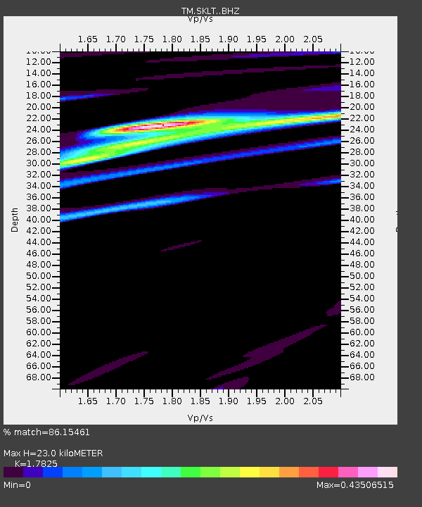
| Estimated Moho Depth: |
23.0 km |
| Estimated Crust Vp/Vs: |
1.78 |
| Assumed Crust Vp: |
6.468 km/s |
| Estimated Crust Vs: |
3.628 km/s |
| Estimated Crust Poisson's Ratio: |
0.27 |
|
| Radial Match: |
86.15461 % |
| Radial Bump: |
400 |
| Transverse Match: |
67.33799 % |
| Transverse Bump: |
400 |
| SOD ConfigId: |
11737051 |
| Insert Time: |
2019-04-25 11:27:56.338 +0000 |
| GWidth: |
2.5 |
| Max Bumps: |
400 |
| Tol: |
0.001 |
|

Signal To Noise
| Channel | StoN | STA | LTA |
| TM:SKLT: :BHZ:20160908T21:57:48.43002Z | 6.205054 | 9.66859E-7 | 1.55818E-7 |
| TM:SKLT: :BHN:20160908T21:57:48.43002Z | 3.592741 | 3.4687577E-7 | 9.654906E-8 |
| TM:SKLT: :BHE:20160908T21:57:48.43002Z | 3.076178 | 3.4360173E-7 | 1.116976E-7 |
| Arrivals |
| Ps | 2.9 SECOND |
| PpPs | 9.6 SECOND |
| PsPs/PpSs | 12 SECOND |


