You are here: Home > Network List > TA - USArray Transportable Network (new EarthScope stations) Stations List
> Station R11A Troy Canyon, Currant, NV, USA > Earthquake Result Viewer
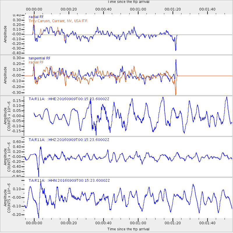
R11A Troy Canyon, Currant, NV, USA - Earthquake Result Viewer
*The percent match for this event was below the threshold and hence no stack was calculated.
| Earthquake location: |
Cordoba Province, Argentina |
| Earthquake latitude/longitude: |
-31.4/-65.7 |
| Earthquake time(UTC): |
2016/09/09 (253) 00:03:43 GMT |
| Earthquake Depth: |
151 km |
| Earthquake Magnitude: |
5.6 MWR |
| Earthquake Catalog/Contributor: |
NEIC PDE/NEIC COMCAT |
|
| Network: |
TA USArray Transportable Network (new EarthScope stations) |
| Station: |
R11A Troy Canyon, Currant, NV, USA |
| Lat/Lon: |
38.35 N/115.59 W |
| Elevation: |
1756 m |
|
| Distance: |
83.5 deg |
| Az: |
322.787 deg |
| Baz: |
138.877 deg |
| Ray Param: |
$rayparam |
*The percent match for this event was below the threshold and hence was not used in the summary stack. |
|
| Radial Match: |
48.028942 % |
| Radial Bump: |
400 |
| Transverse Match: |
59.860836 % |
| Transverse Bump: |
384 |
| SOD ConfigId: |
11737051 |
| Insert Time: |
2019-04-25 11:35:30.768 +0000 |
| GWidth: |
2.5 |
| Max Bumps: |
400 |
| Tol: |
0.001 |
|
Signal To Noise
| Channel | StoN | STA | LTA |
| TA:R11A: :HHZ:20160909T00:15:23.60002Z | 2.284613 | 2.7787596E-7 | 1.2162934E-7 |
| TA:R11A: :HHN:20160909T00:15:23.60002Z | 1.654633 | 1.0749269E-7 | 6.4964674E-8 |
| TA:R11A: :HHE:20160909T00:15:23.60002Z | 2.011756 | 8.960391E-8 | 4.4540148E-8 |
| Arrivals |
| Ps | |
| PpPs | |
| PsPs/PpSs | |


