You are here: Home > Network List > UW - Pacific Northwest Regional Seismic Network Stations List
> Station UMAT Pilot Rock, OR, USA > Earthquake Result Viewer
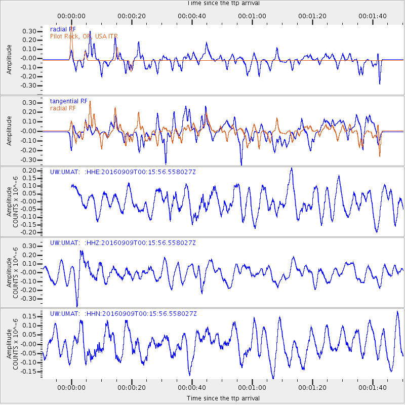
UMAT Pilot Rock, OR, USA - Earthquake Result Viewer
*The percent match for this event was below the threshold and hence no stack was calculated.
| Earthquake location: |
Cordoba Province, Argentina |
| Earthquake latitude/longitude: |
-31.4/-65.7 |
| Earthquake time(UTC): |
2016/09/09 (253) 00:03:43 GMT |
| Earthquake Depth: |
151 km |
| Earthquake Magnitude: |
5.6 MWR |
| Earthquake Catalog/Contributor: |
NEIC PDE/NEIC COMCAT |
|
| Network: |
UW Pacific Northwest Regional Seismic Network |
| Station: |
UMAT Pilot Rock, OR, USA |
| Lat/Lon: |
45.29 N/118.96 W |
| Elevation: |
1318 m |
|
| Distance: |
90.3 deg |
| Az: |
325.574 deg |
| Baz: |
136.781 deg |
| Ray Param: |
$rayparam |
*The percent match for this event was below the threshold and hence was not used in the summary stack. |
|
| Radial Match: |
59.165817 % |
| Radial Bump: |
397 |
| Transverse Match: |
68.65893 % |
| Transverse Bump: |
400 |
| SOD ConfigId: |
11737051 |
| Insert Time: |
2019-04-25 11:36:09.952 +0000 |
| GWidth: |
2.5 |
| Max Bumps: |
400 |
| Tol: |
0.001 |
|
Signal To Noise
| Channel | StoN | STA | LTA |
| UW:UMAT: :HHZ:20160909T00:15:56.558027Z | 3.6477158 | 1.7311942E-7 | 4.745968E-8 |
| UW:UMAT: :HHN:20160909T00:15:56.558027Z | 1.5139523 | 7.602021E-8 | 5.021308E-8 |
| UW:UMAT: :HHE:20160909T00:15:56.558027Z | 0.9217973 | 5.1129298E-8 | 5.5466963E-8 |
| Arrivals |
| Ps | |
| PpPs | |
| PsPs/PpSs | |


