You are here: Home > Network List > US - United States National Seismic Network Stations List
> Station MNV Mina, Nevada, USA > Earthquake Result Viewer
MNV Mina, Nevada, USA - Earthquake Result Viewer
| Earthquake location: |
Mariana Islands Region |
| Earthquake latitude/longitude: |
19.6/146.8 |
| Earthquake time(UTC): |
2004/07/20 (202) 14:16:23 GMT |
| Earthquake Depth: |
13 km |
| Earthquake Magnitude: |
5.7 MB, 5.6 MS, 5.9 MW, 5.9 MW |
| Earthquake Catalog/Contributor: |
WHDF/NEIC |
|
| Network: |
US United States National Seismic Network |
| Station: |
MNV Mina, Nevada, USA |
| Lat/Lon: |
38.43 N/118.15 W |
| Elevation: |
1524 m |
|
| Distance: |
81.8 deg |
| Az: |
52.215 deg |
| Baz: |
288.472 deg |
| Ray Param: |
0.047292322 |
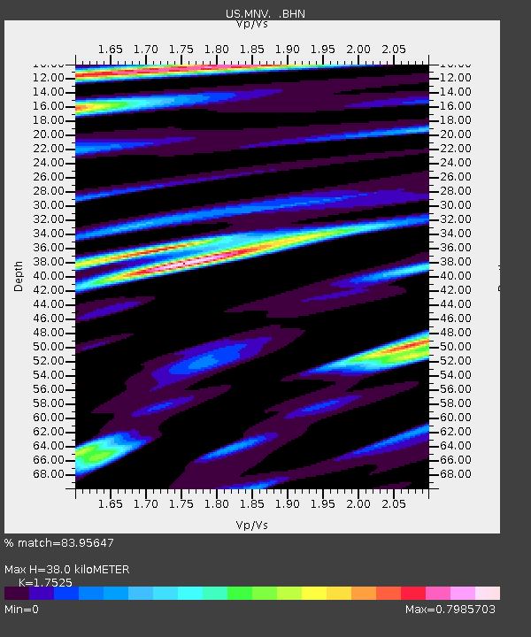
| Estimated Moho Depth: |
38.0 km |
| Estimated Crust Vp/Vs: |
1.75 |
| Assumed Crust Vp: |
6.279 km/s |
| Estimated Crust Vs: |
3.583 km/s |
| Estimated Crust Poisson's Ratio: |
0.26 |
|
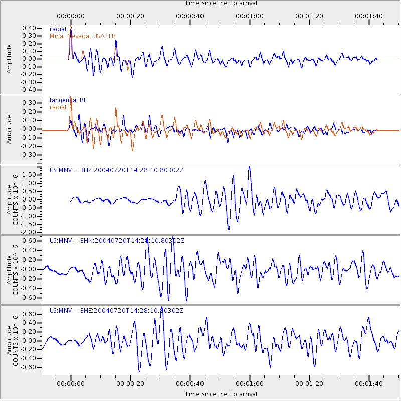
| Radial Match: |
83.95647 % |
| Radial Bump: |
400 |
| Transverse Match: |
83.8235 % |
| Transverse Bump: |
400 |
| SOD ConfigId: |
110165 |
| Insert Time: |
2010-03-05 06:47:30.255 +0000 |
| GWidth: |
2.5 |
| Max Bumps: |
400 |
| Tol: |
0.001 |
|
Signal To Noise
| Channel | StoN | STA | LTA |
| US:MNV: :BHN:20040720T14:28:10.80302Z | 0.9173655 | 6.473338E-8 | 7.056443E-8 |
| US:MNV: :BHE:20040720T14:28:10.80302Z | 0.4857405 | 4.147218E-8 | 8.537929E-8 |
| US:MNV: :BHZ:20040720T14:28:10.80302Z | 1.3658596 | 1.4336861E-7 | 1.0496585E-7 |
| Arrivals |
| Ps | 4.7 SECOND |
| PpPs | 16 SECOND |
| PsPs/PpSs | 21 SECOND |


