You are here: Home > Network List > US - United States National Seismic Network Stations List
> Station MNV Mina, Nevada, USA > Earthquake Result Viewer
MNV Mina, Nevada, USA - Earthquake Result Viewer
| Earthquake location: |
Near Coast Of Guatemala |
| Earthquake latitude/longitude: |
13.4/-90.1 |
| Earthquake time(UTC): |
2004/11/20 (325) 22:01:45 GMT |
| Earthquake Depth: |
41 km |
| Earthquake Magnitude: |
5.6 MB, 6.0 MS, 6.3 MW, 6.2 MW |
| Earthquake Catalog/Contributor: |
WHDF/NEIC |
|
| Network: |
US United States National Seismic Network |
| Station: |
MNV Mina, Nevada, USA |
| Lat/Lon: |
38.43 N/118.15 W |
| Elevation: |
1524 m |
|
| Distance: |
35.3 deg |
| Az: |
320.152 deg |
| Baz: |
127.438 deg |
| Ray Param: |
0.07723147 |
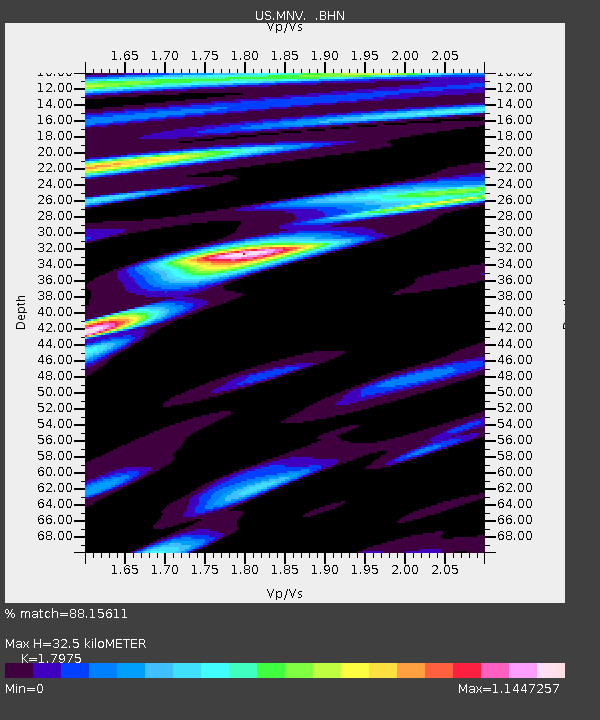
| Estimated Moho Depth: |
32.5 km |
| Estimated Crust Vp/Vs: |
1.80 |
| Assumed Crust Vp: |
6.279 km/s |
| Estimated Crust Vs: |
3.493 km/s |
| Estimated Crust Poisson's Ratio: |
0.28 |
|
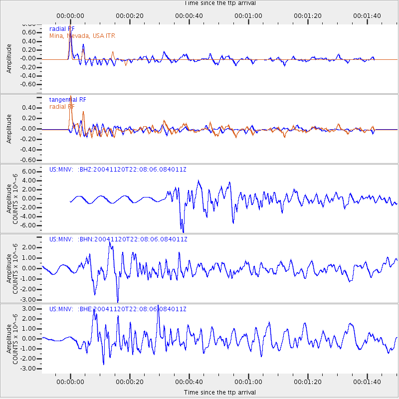
| Radial Match: |
88.15611 % |
| Radial Bump: |
400 |
| Transverse Match: |
67.841705 % |
| Transverse Bump: |
400 |
| SOD ConfigId: |
110177 |
| Insert Time: |
2010-03-05 06:47:33.362 +0000 |
| GWidth: |
2.5 |
| Max Bumps: |
400 |
| Tol: |
0.001 |
|
Signal To Noise
| Channel | StoN | STA | LTA |
| US:MNV: :BHN:20041120T22:08:06.084011Z | 1.2327307 | 3.0594052E-7 | 2.4818112E-7 |
| US:MNV: :BHE:20041120T22:08:06.084011Z | 2.4149294 | 4.9659764E-7 | 2.056365E-7 |
| US:MNV: :BHZ:20041120T22:08:06.084011Z | 1.4718561 | 8.217277E-7 | 5.5829355E-7 |
| Arrivals |
| Ps | 4.4 SECOND |
| PpPs | 13 SECOND |
| PsPs/PpSs | 18 SECOND |


