You are here: Home > Network List > US - United States National Seismic Network Stations List
> Station MNV Mina, Nevada, USA > Earthquake Result Viewer
MNV Mina, Nevada, USA - Earthquake Result Viewer
| Earthquake location: |
Caribbean Sea |
| Earthquake latitude/longitude: |
17.8/-81.6 |
| Earthquake time(UTC): |
2004/09/09 (253) 16:33:21 GMT |
| Earthquake Depth: |
25 km |
| Earthquake Magnitude: |
5.8 MB, 5.4 MS, 6.0 MW, 6.0 MW |
| Earthquake Catalog/Contributor: |
WHDF/NEIC |
|
| Network: |
US United States National Seismic Network |
| Station: |
MNV Mina, Nevada, USA |
| Lat/Lon: |
38.43 N/118.15 W |
| Elevation: |
1524 m |
|
| Distance: |
38.0 deg |
| Az: |
310.416 deg |
| Baz: |
112.51 deg |
| Ray Param: |
0.07579895 |
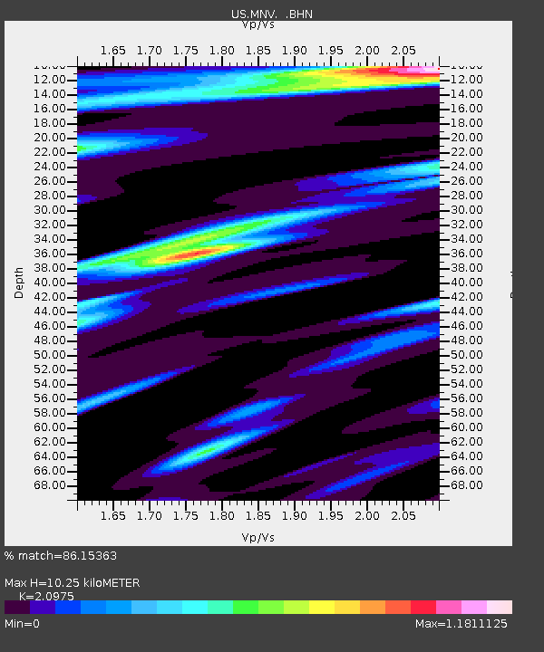
| Estimated Moho Depth: |
10.25 km |
| Estimated Crust Vp/Vs: |
2.10 |
| Assumed Crust Vp: |
6.279 km/s |
| Estimated Crust Vs: |
2.993 km/s |
| Estimated Crust Poisson's Ratio: |
0.35 |
|
| Radial Match: |
86.15363 % |
| Radial Bump: |
338 |
| Transverse Match: |
67.16356 % |
| Transverse Bump: |
400 |
| SOD ConfigId: |
110177 |
| Insert Time: |
2010-03-05 06:47:36.679 +0000 |
| GWidth: |
2.5 |
| Max Bumps: |
400 |
| Tol: |
0.001 |
|
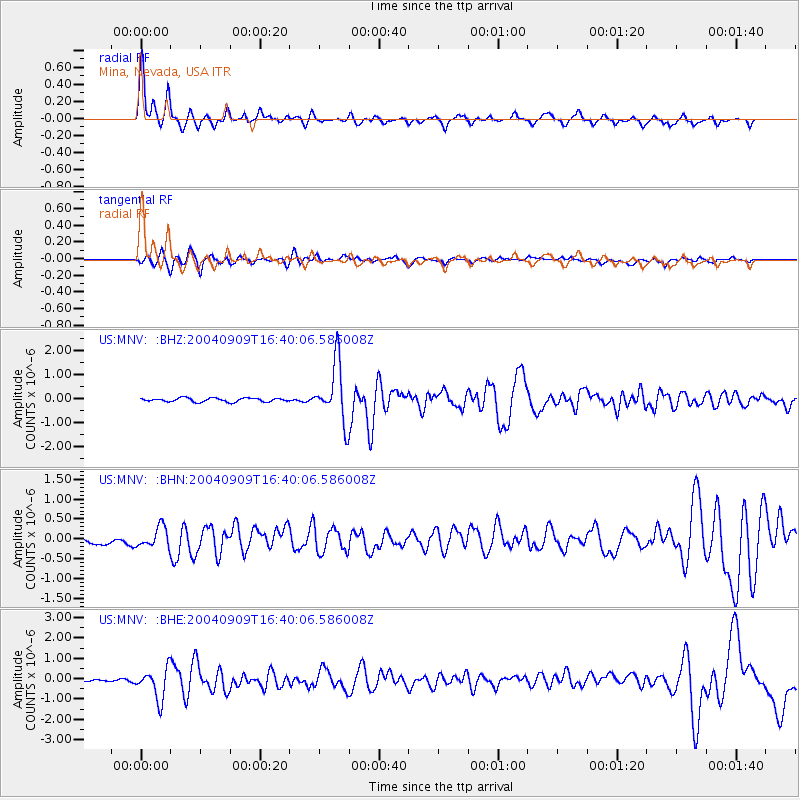
Signal To Noise
| Channel | StoN | STA | LTA |
| US:MNV: :BHN:20040909T16:40:06.586008Z | 2.1594005 | 2.535335E-7 | 1.17409215E-7 |
| US:MNV: :BHE:20040909T16:40:06.586008Z | 8.063817 | 7.528395E-7 | 9.336019E-8 |
| US:MNV: :BHZ:20040909T16:40:06.586008Z | 15.466575 | 1.2175467E-6 | 7.872116E-8 |
| Arrivals |
| Ps | 1.9 SECOND |
| PpPs | 4.8 SECOND |
| PsPs/PpSs | 6.7 SECOND |


