You are here: Home > Network List > US - United States National Seismic Network Stations List
> Station MNV Mina, Nevada, USA > Earthquake Result Viewer
MNV Mina, Nevada, USA - Earthquake Result Viewer
| Earthquake location: |
Southeast Of Loyalty Islands |
| Earthquake latitude/longitude: |
-22.3/169.7 |
| Earthquake time(UTC): |
2004/01/03 (003) 16:23:21 GMT |
| Earthquake Depth: |
22 km |
| Earthquake Magnitude: |
6.4 MB, 7.1 MS, 7.1 MW, 6.8 MW |
| Earthquake Catalog/Contributor: |
WHDF/NEIC |
|
| Network: |
US United States National Seismic Network |
| Station: |
MNV Mina, Nevada, USA |
| Lat/Lon: |
38.43 N/118.15 W |
| Elevation: |
1524 m |
|
| Distance: |
90.6 deg |
| Az: |
48.388 deg |
| Baz: |
241.876 deg |
| Ray Param: |
0.04166084 |
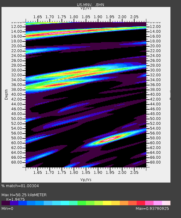
| Estimated Moho Depth: |
58.25 km |
| Estimated Crust Vp/Vs: |
1.95 |
| Assumed Crust Vp: |
6.279 km/s |
| Estimated Crust Vs: |
3.224 km/s |
| Estimated Crust Poisson's Ratio: |
0.32 |
|
| Radial Match: |
81.00304 % |
| Radial Bump: |
400 |
| Transverse Match: |
65.97159 % |
| Transverse Bump: |
400 |
| SOD ConfigId: |
110177 |
| Insert Time: |
2010-03-05 06:47:38.245 +0000 |
| GWidth: |
2.5 |
| Max Bumps: |
400 |
| Tol: |
0.001 |
|
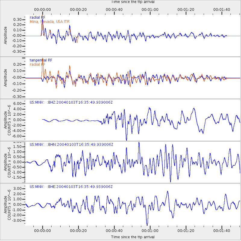
Signal To Noise
| Channel | StoN | STA | LTA |
| US:MNV: :BHN:20040103T16:35:49.939006Z | 1.3328364 | 2.7819743E-7 | 2.0872587E-7 |
| US:MNV: :BHE:20040103T16:35:49.939006Z | 0.9115131 | 3.0597243E-7 | 3.356753E-7 |
| US:MNV: :BHZ:20040103T16:35:49.939006Z | 2.4701257 | 5.8022914E-7 | 2.3489862E-7 |
| Arrivals |
| Ps | 8.9 SECOND |
| PpPs | 27 SECOND |
| PsPs/PpSs | 36 SECOND |


