You are here: Home > Network List > US - United States National Seismic Network Stations List
> Station MNV Mina, Nevada, USA > Earthquake Result Viewer
MNV Mina, Nevada, USA - Earthquake Result Viewer
| Earthquake location: |
Central East Pacific Rise |
| Earthquake latitude/longitude: |
-13.4/-112.2 |
| Earthquake time(UTC): |
2004/08/01 (214) 19:44:47 GMT |
| Earthquake Depth: |
10 km |
| Earthquake Magnitude: |
5.1 MB, 5.6 MS |
| Earthquake Catalog/Contributor: |
WHDF/NEIC |
|
| Network: |
US United States National Seismic Network |
| Station: |
MNV Mina, Nevada, USA |
| Lat/Lon: |
38.43 N/118.15 W |
| Elevation: |
1524 m |
|
| Distance: |
51.8 deg |
| Az: |
354.064 deg |
| Baz: |
172.638 deg |
| Ray Param: |
0.06714526 |
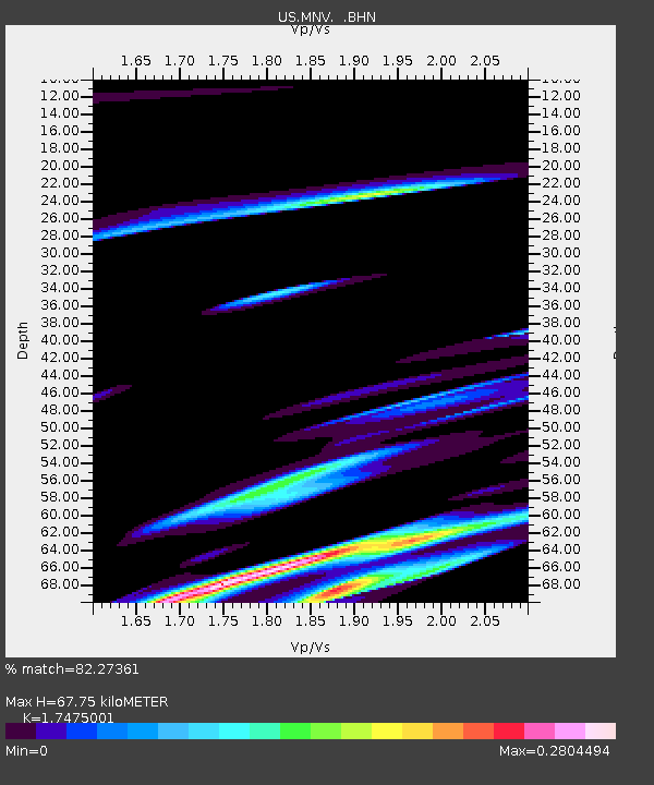
| Estimated Moho Depth: |
67.75 km |
| Estimated Crust Vp/Vs: |
1.75 |
| Assumed Crust Vp: |
6.279 km/s |
| Estimated Crust Vs: |
3.593 km/s |
| Estimated Crust Poisson's Ratio: |
0.26 |
|
| Radial Match: |
82.27361 % |
| Radial Bump: |
387 |
| Transverse Match: |
87.82593 % |
| Transverse Bump: |
400 |
| SOD ConfigId: |
110177 |
| Insert Time: |
2010-03-05 06:47:40.775 +0000 |
| GWidth: |
2.5 |
| Max Bumps: |
400 |
| Tol: |
0.001 |
|
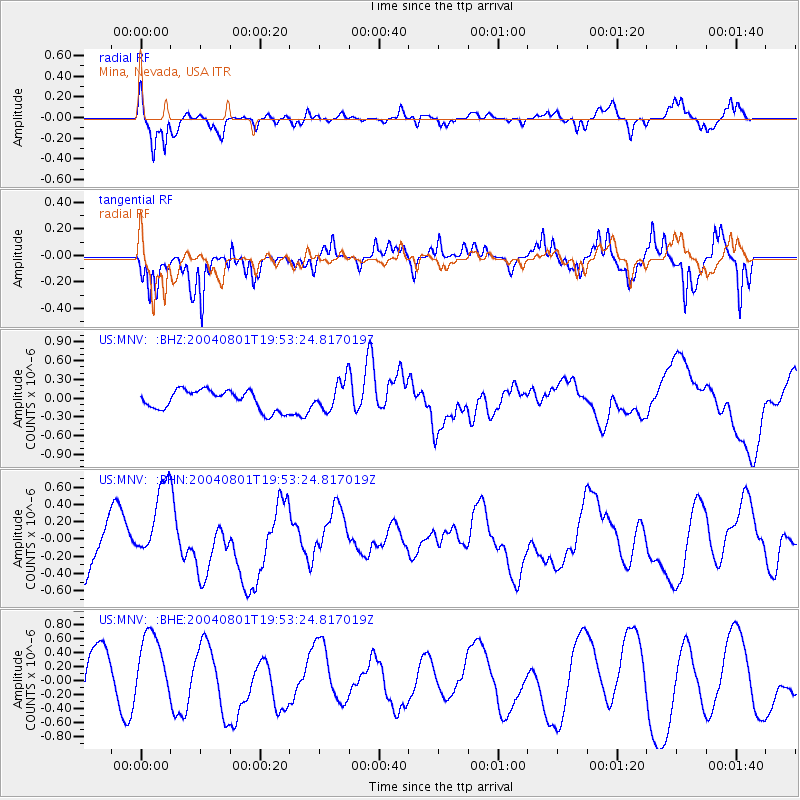
Signal To Noise
| Channel | StoN | STA | LTA |
| US:MNV: :BHN:20040801T19:53:24.817019Z | 2.5706534 | 4.9279413E-7 | 1.9169994E-7 |
| US:MNV: :BHE:20040801T19:53:24.817019Z | 1.1312978 | 5.1842835E-7 | 4.5825982E-7 |
| US:MNV: :BHZ:20040801T19:53:24.817019Z | 1.517364 | 2.4136233E-7 | 1.5906686E-7 |
| Arrivals |
| Ps | 8.5 SECOND |
| PpPs | 28 SECOND |
| PsPs/PpSs | 37 SECOND |


