You are here: Home > Network List > US - United States National Seismic Network Stations List
> Station MNV Mina, Nevada, USA > Earthquake Result Viewer
MNV Mina, Nevada, USA - Earthquake Result Viewer
| Earthquake location: |
South Of Aleutian Islands |
| Earthquake latitude/longitude: |
51.8/-166.3 |
| Earthquake time(UTC): |
2004/08/07 (220) 09:30:16 GMT |
| Earthquake Depth: |
8.0 km |
| Earthquake Magnitude: |
6.3 MB, 5.4 MS, 6.0 MW, 6.0 MW |
| Earthquake Catalog/Contributor: |
WHDF/NEIC |
|
| Network: |
US United States National Seismic Network |
| Station: |
MNV Mina, Nevada, USA |
| Lat/Lon: |
38.43 N/118.15 W |
| Elevation: |
1524 m |
|
| Distance: |
35.8 deg |
| Az: |
92.502 deg |
| Baz: |
307.745 deg |
| Ray Param: |
0.07700596 |
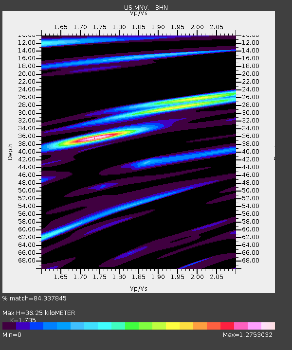
| Estimated Moho Depth: |
36.25 km |
| Estimated Crust Vp/Vs: |
1.74 |
| Assumed Crust Vp: |
6.279 km/s |
| Estimated Crust Vs: |
3.619 km/s |
| Estimated Crust Poisson's Ratio: |
0.25 |
|
| Radial Match: |
84.337845 % |
| Radial Bump: |
400 |
| Transverse Match: |
75.88411 % |
| Transverse Bump: |
400 |
| SOD ConfigId: |
110177 |
| Insert Time: |
2010-03-05 06:47:42.433 +0000 |
| GWidth: |
2.5 |
| Max Bumps: |
400 |
| Tol: |
0.001 |
|
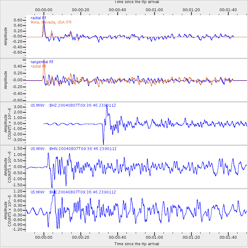
Signal To Noise
| Channel | StoN | STA | LTA |
| US:MNV: :BHN:20040807T09:36:46.239011Z | 9.482093 | 6.7278296E-7 | 7.095301E-8 |
| US:MNV: :BHE:20040807T09:36:46.239011Z | 3.9378114 | 4.1768644E-7 | 1.0607071E-7 |
| US:MNV: :BHZ:20040807T09:36:46.239011Z | 15.160321 | 1.5541193E-6 | 1.02512296E-7 |
| Arrivals |
| Ps | 4.6 SECOND |
| PpPs | 15 SECOND |
| PsPs/PpSs | 19 SECOND |


