You are here: Home > Network List > US - United States National Seismic Network Stations List
> Station MNV Mina, Nevada, USA > Earthquake Result Viewer
MNV Mina, Nevada, USA - Earthquake Result Viewer
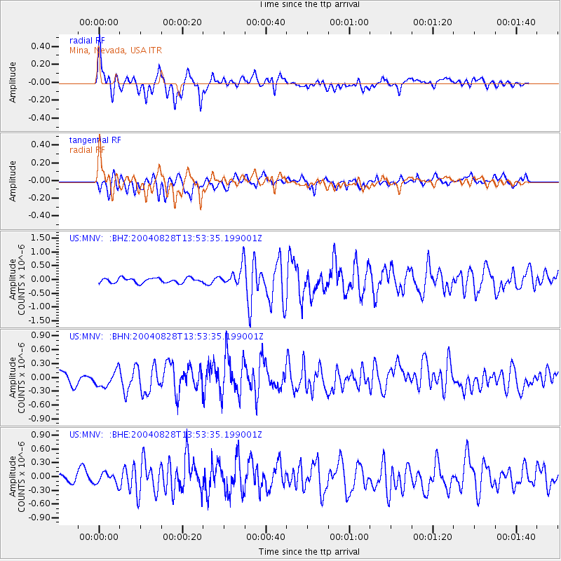
| Earthquake location: |
Chile-Argentina Border Region |
| Earthquake latitude/longitude: |
-34.9/-70.4 |
| Earthquake time(UTC): |
2004/08/28 (241) 13:41:27 GMT |
| Earthquake Depth: |
1.0 km |
| Earthquake Magnitude: |
6.1 MB, 6.3 MS, 6.5 MW, 6.5 MW |
| Earthquake Catalog/Contributor: |
WHDF/NEIC |
|
| Network: |
US United States National Seismic Network |
| Station: |
MNV Mina, Nevada, USA |
| Lat/Lon: |
38.43 N/118.15 W |
| Elevation: |
1524 m |
|
| Distance: |
85.4 deg |
| Az: |
324.31 deg |
| Baz: |
142.385 deg |
| Ray Param: |
0.04483557 |
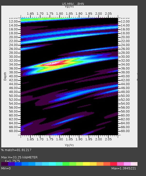
| Estimated Moho Depth: |
33.25 km |
| Estimated Crust Vp/Vs: |
1.76 |
| Assumed Crust Vp: |
6.279 km/s |
| Estimated Crust Vs: |
3.572 km/s |
| Estimated Crust Poisson's Ratio: |
0.26 |
|
| Radial Match: |
81.91217 % |
| Radial Bump: |
400 |
| Transverse Match: |
62.64051 % |
| Transverse Bump: |
400 |
| SOD ConfigId: |
110177 |
| Insert Time: |
2010-03-05 06:47:45.203 +0000 |
| GWidth: |
2.5 |
| Max Bumps: |
400 |
| Tol: |
0.001 |
|
Signal To Noise
| Channel | StoN | STA | LTA |
| US:MNV: :BHN:20040828T13:53:35.199001Z | 1.791902 | 1.8620722E-7 | 1.0391596E-7 |
| US:MNV: :BHE:20040828T13:53:35.199001Z | 0.67602396 | 1.2150194E-7 | 1.7973022E-7 |
| US:MNV: :BHZ:20040828T13:53:35.199001Z | 4.4640155 | 3.852163E-7 | 8.629368E-8 |
| Arrivals |
| Ps | 4.1 SECOND |
| PpPs | 14 SECOND |
| PsPs/PpSs | 18 SECOND |


