You are here: Home > Network List > US - United States National Seismic Network Stations List
> Station MNV Mina, Nevada, USA > Earthquake Result Viewer
MNV Mina, Nevada, USA - Earthquake Result Viewer
| Earthquake location: |
Near S. Coast Of Honshu, Japan |
| Earthquake latitude/longitude: |
33.1/137.2 |
| Earthquake time(UTC): |
2004/09/08 (252) 14:58:25 GMT |
| Earthquake Depth: |
21 km |
| Earthquake Magnitude: |
6.2 MB, 5.8 MS, 6.2 MW, 6.1 MW |
| Earthquake Catalog/Contributor: |
WHDF/NEIC |
|
| Network: |
US United States National Seismic Network |
| Station: |
MNV Mina, Nevada, USA |
| Lat/Lon: |
38.43 N/118.15 W |
| Elevation: |
1524 m |
|
| Distance: |
80.2 deg |
| Az: |
50.452 deg |
| Baz: |
304.536 deg |
| Ray Param: |
0.048418447 |
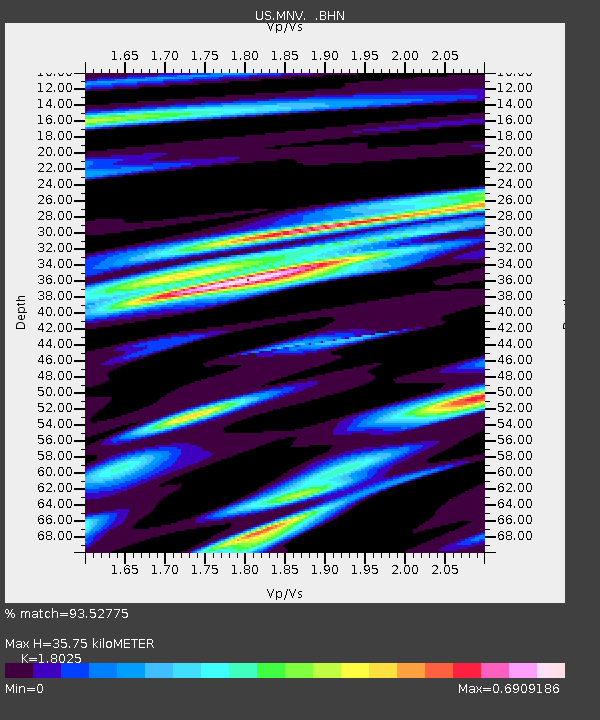
| Estimated Moho Depth: |
35.75 km |
| Estimated Crust Vp/Vs: |
1.80 |
| Assumed Crust Vp: |
6.279 km/s |
| Estimated Crust Vs: |
3.483 km/s |
| Estimated Crust Poisson's Ratio: |
0.28 |
|
| Radial Match: |
93.52775 % |
| Radial Bump: |
400 |
| Transverse Match: |
89.61755 % |
| Transverse Bump: |
391 |
| SOD ConfigId: |
110177 |
| Insert Time: |
2010-03-05 06:47:49.014 +0000 |
| GWidth: |
2.5 |
| Max Bumps: |
400 |
| Tol: |
0.001 |
|
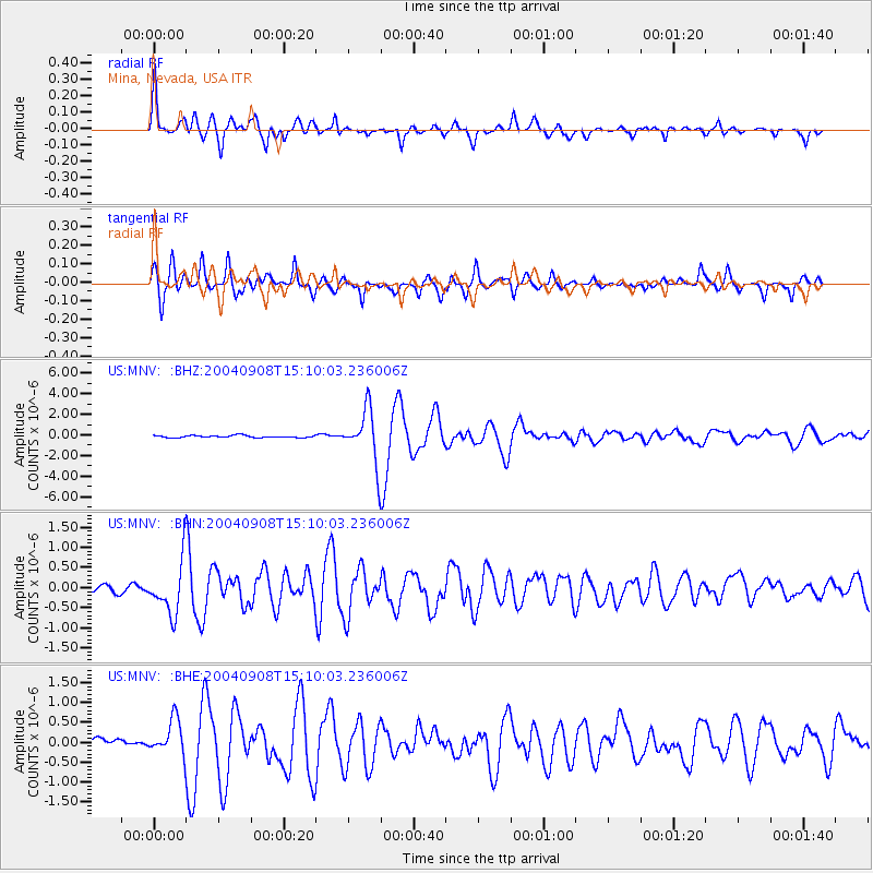
Signal To Noise
| Channel | StoN | STA | LTA |
| US:MNV: :BHN:20040908T15:10:03.236006Z | 5.204166 | 6.5390935E-7 | 1.2565114E-7 |
| US:MNV: :BHE:20040908T15:10:03.236006Z | 3.886809 | 4.3229264E-7 | 1.11220444E-7 |
| US:MNV: :BHZ:20040908T15:10:03.236006Z | 25.968344 | 2.5635416E-6 | 9.871795E-8 |
| Arrivals |
| Ps | 4.7 SECOND |
| PpPs | 16 SECOND |
| PsPs/PpSs | 20 SECOND |


