You are here: Home > Network List > US - United States National Seismic Network Stations List
> Station MNV Mina, Nevada, USA > Earthquake Result Viewer
MNV Mina, Nevada, USA - Earthquake Result Viewer
| Earthquake location: |
Near Coast Of Nicaragua |
| Earthquake latitude/longitude: |
11.4/-86.7 |
| Earthquake time(UTC): |
2004/10/09 (283) 21:26:53 GMT |
| Earthquake Depth: |
35 km |
| Earthquake Magnitude: |
6.0 MB, 7.0 MS, 6.9 MW, 6.8 MW |
| Earthquake Catalog/Contributor: |
WHDF/NEIC |
|
| Network: |
US United States National Seismic Network |
| Station: |
MNV Mina, Nevada, USA |
| Lat/Lon: |
38.43 N/118.15 W |
| Elevation: |
1524 m |
|
| Distance: |
38.9 deg |
| Az: |
319.195 deg |
| Baz: |
125.333 deg |
| Ray Param: |
0.07523529 |
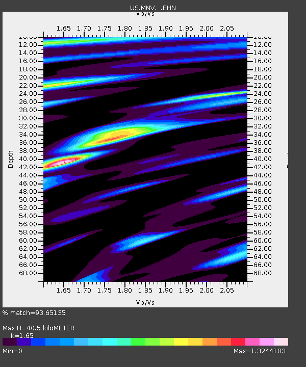
| Estimated Moho Depth: |
40.5 km |
| Estimated Crust Vp/Vs: |
1.65 |
| Assumed Crust Vp: |
6.279 km/s |
| Estimated Crust Vs: |
3.805 km/s |
| Estimated Crust Poisson's Ratio: |
0.21 |
|
| Radial Match: |
93.65135 % |
| Radial Bump: |
374 |
| Transverse Match: |
76.18392 % |
| Transverse Bump: |
400 |
| SOD ConfigId: |
110177 |
| Insert Time: |
2010-03-05 06:47:51.064 +0000 |
| GWidth: |
2.5 |
| Max Bumps: |
400 |
| Tol: |
0.001 |
|
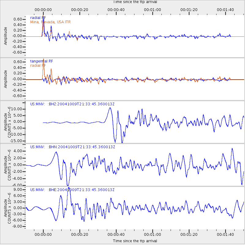
Signal To Noise
| Channel | StoN | STA | LTA |
| US:MNV: :BHN:20041009T21:33:45.360013Z | 1.456532 | 4.3522178E-7 | 2.9880687E-7 |
| US:MNV: :BHE:20041009T21:33:45.360013Z | 0.71947867 | 5.0399655E-7 | 7.0050237E-7 |
| US:MNV: :BHZ:20041009T21:33:45.360013Z | 3.7643628 | 1.1095276E-6 | 2.9474515E-7 |
| Arrivals |
| Ps | 4.5 SECOND |
| PpPs | 16 SECOND |
| PsPs/PpSs | 20 SECOND |


