MNV Mina, Nevada, USA - Earthquake Result Viewer
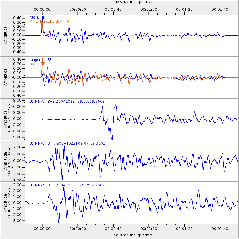
Earthquake location: Near West Coast Of Honshu, Japan
Earthquake latitude/longitude: 37.2/138.8
Earthquake time(UTC): 2004/10/23 (297) 08:56:00 GMT
Earthquake Depth: 16 km
Earthquake Magnitude: 6.4 MB, 6.3 MS, 6.6 MW, 6.4 MW
Earthquake Catalog/Contributor: WHDF/NEIC
Network: US United States National Seismic Network
Station: MNV Mina, Nevada, USA
Lat/Lon: 38.43 N/118.15 W
Elevation: 1524 m
Distance: 76.6 deg
Az: 51.843 deg
Baz: 306.948 deg
Ray Param: 0.05085067
Estimated Moho Depth: 26.0 km
Estimated Crust Vp/Vs: 2.06
Assumed Crust Vp: 6.279 km/s
Estimated Crust Vs: 3.052 km/s
Estimated Crust Poisson's Ratio: 0.35
Radial Match: 90.62504 %
Radial Bump: 400
Transverse Match: 89.345375 %
Transverse Bump: 400
SOD ConfigId: 110177
Insert Time: 2010-03-05 06:47:52.609 +0000
GWidth: 2.5
Max Bumps: 400
Tol: 0.001

Signal To Noise

ChannelStoNSTALTA
US:MNV: :BHN:20041023T09:07:19.360Z4.47523984.7321848E-71.0574148E-7
US:MNV: :BHE:20041023T09:07:19.360Z4.2543686.0679105E-71.4262777E-7
US:MNV: :BHZ:20041023T09:07:19.360Z17.8306262.2463933E-61.259851E-7
Arrivals
Ps4.5 SECOND
PpPs12 SECOND
PsPs/PpSs17 SECOND