You are here: Home > Network List > US - United States National Seismic Network Stations List
> Station MNV Mina, Nevada, USA > Earthquake Result Viewer
MNV Mina, Nevada, USA - Earthquake Result Viewer
| Earthquake location: |
Off Coast Of Central America |
| Earthquake latitude/longitude: |
12.2/-88.3 |
| Earthquake time(UTC): |
1995/06/14 (165) 11:11:49 GMT |
| Earthquake Depth: |
39 km |
| Earthquake Magnitude: |
5.6 MB, 6.0 MS, 6.6 UNKNOWN |
| Earthquake Catalog/Contributor: |
WHDF/NEIC |
|
| Network: |
US United States National Seismic Network |
| Station: |
MNV Mina, Nevada, USA |
| Lat/Lon: |
38.43 N/118.15 W |
| Elevation: |
1524 m |
|
| Distance: |
37.2 deg |
| Az: |
319.81 deg |
| Baz: |
126.548 deg |
| Ray Param: |
0.07617193 |
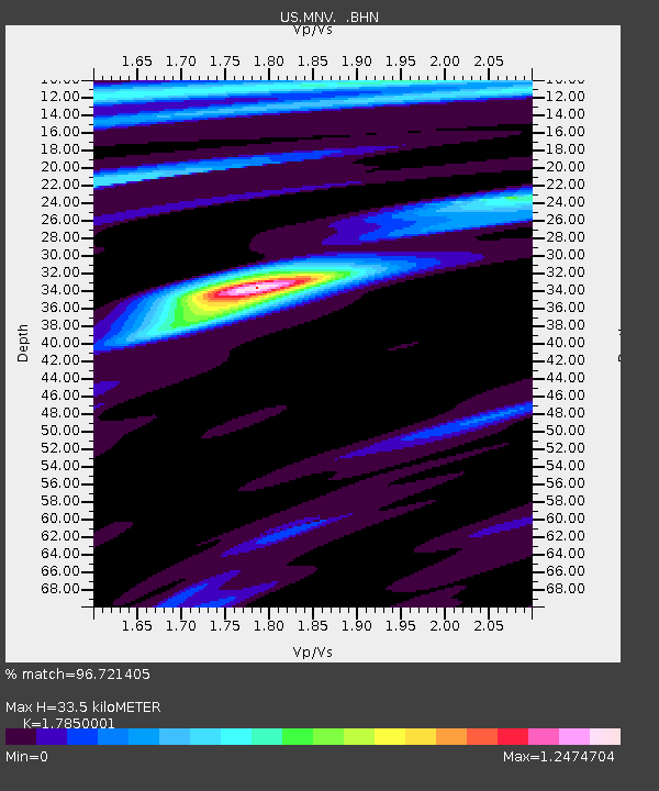
| Estimated Moho Depth: |
33.5 km |
| Estimated Crust Vp/Vs: |
1.79 |
| Assumed Crust Vp: |
6.279 km/s |
| Estimated Crust Vs: |
3.517 km/s |
| Estimated Crust Poisson's Ratio: |
0.27 |
|
| Radial Match: |
96.721405 % |
| Radial Bump: |
315 |
| Transverse Match: |
93.47848 % |
| Transverse Bump: |
400 |
| SOD ConfigId: |
110177 |
| Insert Time: |
2010-03-05 06:48:05.219 +0000 |
| GWidth: |
2.5 |
| Max Bumps: |
400 |
| Tol: |
0.001 |
|
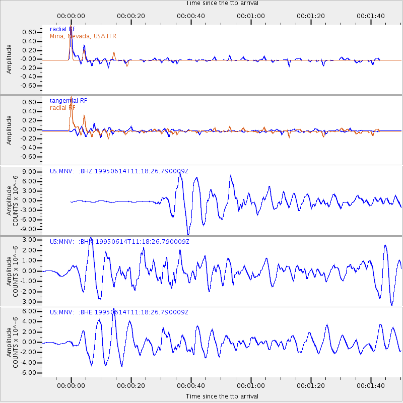
Signal To Noise
| Channel | StoN | STA | LTA |
| US:MNV: :BHN:19950614T11:18:26.790009Z | 5.2703133 | 8.845224E-7 | 1.6783109E-7 |
| US:MNV: :BHE:19950614T11:18:26.790009Z | 8.854215 | 1.0270338E-6 | 1.1599378E-7 |
| US:MNV: :BHZ:19950614T11:18:26.790009Z | 13.9725895 | 2.1654862E-6 | 1.5498104E-7 |
| Arrivals |
| Ps | 4.5 SECOND |
| PpPs | 14 SECOND |
| PsPs/PpSs | 18 SECOND |


