You are here: Home > Network List > US - United States National Seismic Network Stations List
> Station MNV Mina, Nevada, USA > Earthquake Result Viewer
MNV Mina, Nevada, USA - Earthquake Result Viewer
| Earthquake location: |
Vanuatu Islands |
| Earthquake latitude/longitude: |
-13.5/167.1 |
| Earthquake time(UTC): |
1996/06/10 (162) 01:04:46 GMT |
| Earthquake Depth: |
200 km |
| Earthquake Magnitude: |
5.8 MB, 5.9 MS, 6.7 UNKNOWN, 6.0 MS |
| Earthquake Catalog/Contributor: |
WHDF/NEIC |
|
| Network: |
US United States National Seismic Network |
| Station: |
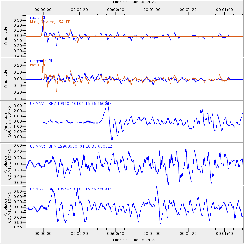
MNV Mina, Nevada, USA |
| Lat/Lon: |
38.43 N/118.15 W |
| Elevation: |
1524 m |
|
| Distance: |
86.7 deg |
| Az: |
49.364 deg |
| Baz: |
250.048 deg |
| Ray Param: |
0.043406997 |
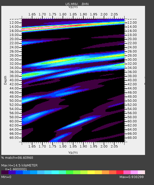
| Estimated Moho Depth: |
14.5 km |
| Estimated Crust Vp/Vs: |
1.68 |
| Assumed Crust Vp: |
6.279 km/s |
| Estimated Crust Vs: |
3.737 km/s |
| Estimated Crust Poisson's Ratio: |
0.23 |
|
| Radial Match: |
86.60968 % |
| Radial Bump: |
400 |
| Transverse Match: |
68.26732 % |
| Transverse Bump: |
400 |
| SOD ConfigId: |
110177 |
| Insert Time: |
2010-03-05 06:48:07.514 +0000 |
| GWidth: |
2.5 |
| Max Bumps: |
400 |
| Tol: |
0.001 |
|
Signal To Noise
| Channel | StoN | STA | LTA |
| US:MNV: :BHN:19960610T01:16:36.66001Z | 1.3330674 | 1.0052837E-7 | 7.5411315E-8 |
| US:MNV: :BHE:19960610T01:16:36.66001Z | 2.1343584 | 2.6821033E-7 | 1.256632E-7 |
| US:MNV: :BHZ:19960610T01:16:36.66001Z | 10.639107 | 1.2995519E-6 | 1.2214859E-7 |
| Arrivals |
| Ps | 1.6 SECOND |
| PpPs | 6.1 SECOND |
| PsPs/PpSs | 7.7 SECOND |


