You are here: Home > Network List > AV - Alaska Volcano Observatory Stations List
> Station MAPS Pakushin Southeast, Makushin Volcano, Alaska > Earthquake Result Viewer
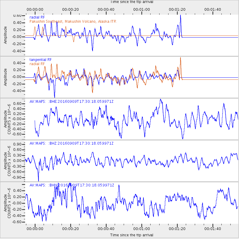
MAPS Pakushin Southeast, Makushin Volcano, Alaska - Earthquake Result Viewer
*The percent match for this event was below the threshold and hence no stack was calculated.
| Earthquake location: |
Northern Mid-Atlantic Ridge |
| Earthquake latitude/longitude: |
22.1/-45.9 |
| Earthquake time(UTC): |
2016/09/09 (253) 17:17:54 GMT |
| Earthquake Depth: |
10 km |
| Earthquake Magnitude: |
5.5 MB |
| Earthquake Catalog/Contributor: |
NEIC PDE/NEIC COMCAT |
|
| Network: |
AV Alaska Volcano Observatory |
| Station: |
MAPS Pakushin Southeast, Makushin Volcano, Alaska |
| Lat/Lon: |
53.81 N/166.94 W |
| Elevation: |
333 m |
|
| Distance: |
89.0 deg |
| Az: |
329.47 deg |
| Baz: |
52.589 deg |
| Ray Param: |
$rayparam |
*The percent match for this event was below the threshold and hence was not used in the summary stack. |
|
| Radial Match: |
50.62893 % |
| Radial Bump: |
400 |
| Transverse Match: |
56.16478 % |
| Transverse Bump: |
290 |
| SOD ConfigId: |
11737051 |
| Insert Time: |
2019-04-25 11:39:34.538 +0000 |
| GWidth: |
2.5 |
| Max Bumps: |
400 |
| Tol: |
0.001 |
|
Signal To Noise
| Channel | StoN | STA | LTA |
| AV:MAPS: :BHZ:20160909T17:30:18.059971Z | 1.9281635 | 4.1613146E-7 | 2.1581751E-7 |
| AV:MAPS: :BHN:20160909T17:30:18.059971Z | 1.7016146 | 3.3432354E-7 | 1.964743E-7 |
| AV:MAPS: :BHE:20160909T17:30:18.059971Z | 0.5510513 | 1.3540921E-7 | 2.4572884E-7 |
| Arrivals |
| Ps | |
| PpPs | |
| PsPs/PpSs | |


