You are here: Home > Network List > US - United States National Seismic Network Stations List
> Station MNV Mina, Nevada, USA > Earthquake Result Viewer
MNV Mina, Nevada, USA - Earthquake Result Viewer
| Earthquake location: |
Tonga Islands |
| Earthquake latitude/longitude: |
-15.3/-173.1 |
| Earthquake time(UTC): |
1996/08/05 (218) 02:08:58 GMT |
| Earthquake Depth: |
41 km |
| Earthquake Magnitude: |
6.0 MB, 6.7 MS, 6.7 UNKNOWN, 6.2 ME |
| Earthquake Catalog/Contributor: |
WHDF/NEIC |
|
| Network: |
US United States National Seismic Network |
| Station: |
MNV Mina, Nevada, USA |
| Lat/Lon: |
38.43 N/118.15 W |
| Elevation: |
1524 m |
|
| Distance: |
74.2 deg |
| Az: |
41.954 deg |
| Baz: |
235.243 deg |
| Ray Param: |
0.05245576 |
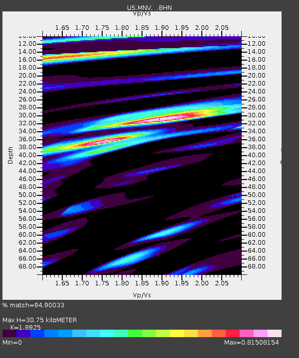
| Estimated Moho Depth: |
30.75 km |
| Estimated Crust Vp/Vs: |
1.89 |
| Assumed Crust Vp: |
6.279 km/s |
| Estimated Crust Vs: |
3.318 km/s |
| Estimated Crust Poisson's Ratio: |
0.31 |
|
| Radial Match: |
94.90033 % |
| Radial Bump: |
400 |
| Transverse Match: |
83.74369 % |
| Transverse Bump: |
400 |
| SOD ConfigId: |
110177 |
| Insert Time: |
2010-03-05 06:48:12.005 +0000 |
| GWidth: |
2.5 |
| Max Bumps: |
400 |
| Tol: |
0.001 |
|
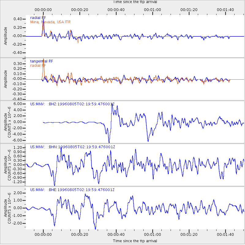
Signal To Noise
| Channel | StoN | STA | LTA |
| US:MNV: :BHN:19960805T02:19:59.476001Z | 3.2064333 | 2.7550132E-7 | 8.592143E-8 |
| US:MNV: :BHE:19960805T02:19:59.476001Z | 2.5598783 | 3.305946E-7 | 1.2914464E-7 |
| US:MNV: :BHZ:19960805T02:19:59.476001Z | 10.472128 | 1.3670748E-6 | 1.3054412E-7 |
| Arrivals |
| Ps | 4.5 SECOND |
| PpPs | 14 SECOND |
| PsPs/PpSs | 18 SECOND |


