You are here: Home > Network List > US - United States National Seismic Network Stations List
> Station MNV Mina, Nevada, USA > Earthquake Result Viewer
MNV Mina, Nevada, USA - Earthquake Result Viewer
| Earthquake location: |
Mexico-Guatemala Border Region |
| Earthquake latitude/longitude: |
15.1/-91.4 |
| Earthquake time(UTC): |
2005/03/17 (076) 13:37:37 GMT |
| Earthquake Depth: |
197 km |
| Earthquake Magnitude: |
5.5 MB, 6.2 MW, 6.2 MW |
| Earthquake Catalog/Contributor: |
WHDF/NEIC |
|
| Network: |
US United States National Seismic Network |
| Station: |
MNV Mina, Nevada, USA |
| Lat/Lon: |
38.43 N/118.15 W |
| Elevation: |
1524 m |
|
| Distance: |
33.1 deg |
| Az: |
319.607 deg |
| Baz: |
127.171 deg |
| Ray Param: |
0.07773223 |
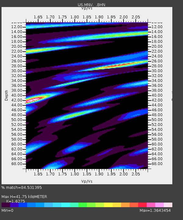
| Estimated Moho Depth: |
41.75 km |
| Estimated Crust Vp/Vs: |
1.63 |
| Assumed Crust Vp: |
6.279 km/s |
| Estimated Crust Vs: |
3.858 km/s |
| Estimated Crust Poisson's Ratio: |
0.20 |
|
| Radial Match: |
84.531395 % |
| Radial Bump: |
345 |
| Transverse Match: |
67.30808 % |
| Transverse Bump: |
400 |
| SOD ConfigId: |
110177 |
| Insert Time: |
2010-03-05 06:48:18.670 +0000 |
| GWidth: |
2.5 |
| Max Bumps: |
400 |
| Tol: |
0.001 |
|
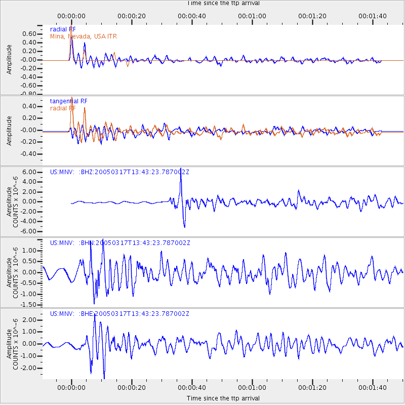
Signal To Noise
| Channel | StoN | STA | LTA |
| US:MNV: :BHN:20050317T13:43:23.787002Z | 2.537029 | 3.4779313E-7 | 1.3708679E-7 |
| US:MNV: :BHE:20050317T13:43:23.787002Z | 1.3290324 | 2.5506867E-7 | 1.9192056E-7 |
| US:MNV: :BHZ:20050317T13:43:23.787002Z | 3.3131342 | 4.4438963E-7 | 1.3412968E-7 |
| Arrivals |
| Ps | 4.5 SECOND |
| PpPs | 16 SECOND |
| PsPs/PpSs | 21 SECOND |


