You are here: Home > Network List > US - United States National Seismic Network Stations List
> Station MNV Mina, Nevada, USA > Earthquake Result Viewer
MNV Mina, Nevada, USA - Earthquake Result Viewer
| Earthquake location: |
Near East Coast Of Honshu, Japan |
| Earthquake latitude/longitude: |
38.1/142.1 |
| Earthquake time(UTC): |
2005/12/02 (336) 13:13:09 GMT |
| Earthquake Depth: |
29 km |
| Earthquake Magnitude: |
6.1 MB, 6.3 MS, 6.5 MW, 6.4 MW |
| Earthquake Catalog/Contributor: |
WHDF/NEIC |
|
| Network: |
US United States National Seismic Network |
| Station: |
MNV Mina, Nevada, USA |
| Lat/Lon: |
38.43 N/118.15 W |
| Elevation: |
1524 m |
|
| Distance: |
74.0 deg |
| Az: |
53.636 deg |
| Baz: |
305.996 deg |
| Ray Param: |
0.052587226 |
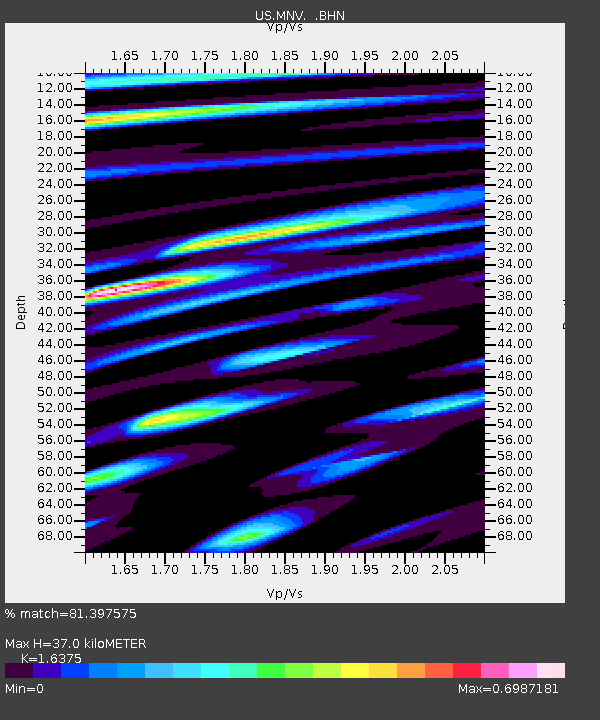
| Estimated Moho Depth: |
37.0 km |
| Estimated Crust Vp/Vs: |
1.64 |
| Assumed Crust Vp: |
6.279 km/s |
| Estimated Crust Vs: |
3.834 km/s |
| Estimated Crust Poisson's Ratio: |
0.20 |
|
| Radial Match: |
81.397575 % |
| Radial Bump: |
400 |
| Transverse Match: |
77.17406 % |
| Transverse Bump: |
400 |
| SOD ConfigId: |
2422 |
| Insert Time: |
2010-03-05 06:48:21.878 +0000 |
| GWidth: |
2.5 |
| Max Bumps: |
400 |
| Tol: |
0.001 |
|
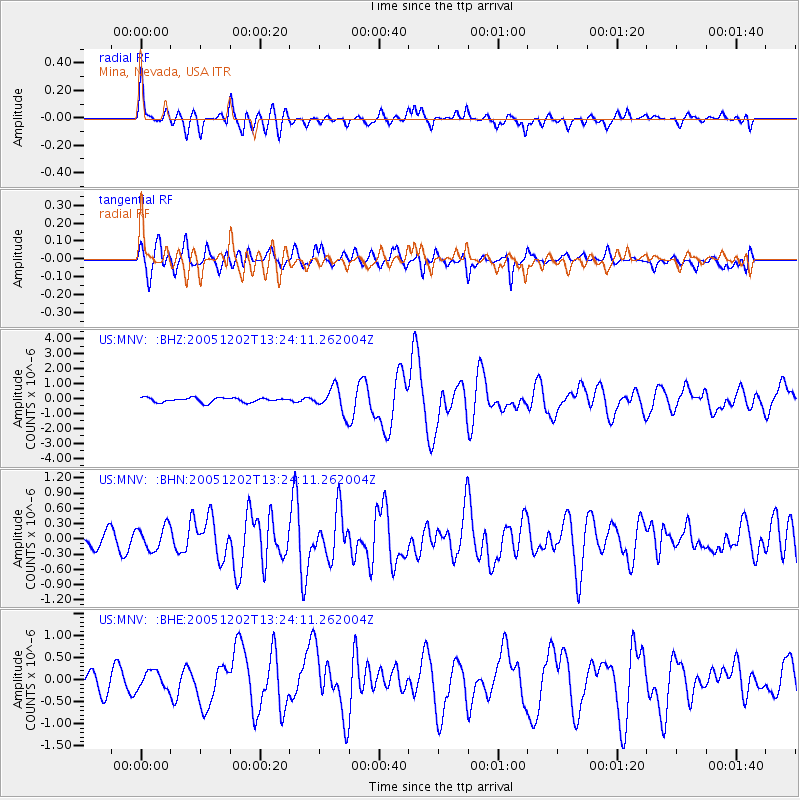
Signal To Noise
| Channel | StoN | STA | LTA |
| US:MNV: :BHN:20051202T13:24:11.262004Z | 1.4681741 | 2.2949249E-7 | 1.563115E-7 |
| US:MNV: :BHE:20051202T13:24:11.262004Z | 1.247675 | 2.0306646E-7 | 1.627559E-7 |
| US:MNV: :BHZ:20051202T13:24:11.262004Z | 5.597523 | 8.409773E-7 | 1.5024096E-7 |
| Arrivals |
| Ps | 3.9 SECOND |
| PpPs | 15 SECOND |
| PsPs/PpSs | 19 SECOND |


