You are here: Home > Network List > US - United States National Seismic Network Stations List
> Station MNV Mina, Nevada, USA > Earthquake Result Viewer
MNV Mina, Nevada, USA - Earthquake Result Viewer
| Earthquake location: |
Caribbean Sea |
| Earthquake latitude/longitude: |
16.1/-87.5 |
| Earthquake time(UTC): |
2005/09/23 (266) 13:48:31 GMT |
| Earthquake Depth: |
30 km |
| Earthquake Magnitude: |
5.9 MB, 5.4 MS, 5.9 MW, 5.9 MW |
| Earthquake Catalog/Contributor: |
WHDF/NEIC |
|
| Network: |
US United States National Seismic Network |
| Station: |
MNV Mina, Nevada, USA |
| Lat/Lon: |
38.43 N/118.15 W |
| Elevation: |
1524 m |
|
| Distance: |
34.9 deg |
| Az: |
315.559 deg |
| Baz: |
121.033 deg |
| Ray Param: |
0.07745526 |
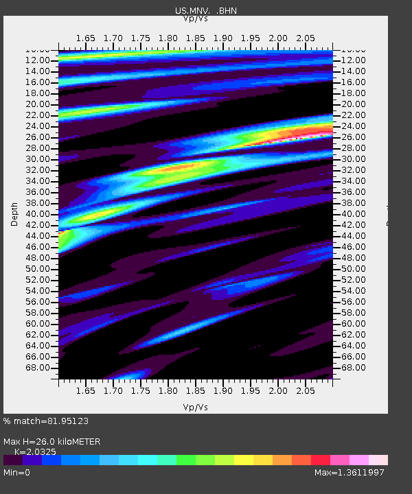
| Estimated Moho Depth: |
26.0 km |
| Estimated Crust Vp/Vs: |
2.03 |
| Assumed Crust Vp: |
6.279 km/s |
| Estimated Crust Vs: |
3.089 km/s |
| Estimated Crust Poisson's Ratio: |
0.34 |
|
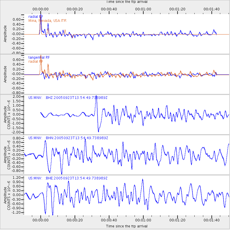
| Radial Match: |
81.95123 % |
| Radial Bump: |
400 |
| Transverse Match: |
49.78609 % |
| Transverse Bump: |
400 |
| SOD ConfigId: |
2422 |
| Insert Time: |
2010-03-05 06:48:25.175 +0000 |
| GWidth: |
2.5 |
| Max Bumps: |
400 |
| Tol: |
0.001 |
|
Signal To Noise
| Channel | StoN | STA | LTA |
| US:MNV: :BHN:20050923T13:54:49.738989Z | 3.0058885 | 3.6995027E-7 | 1.2307518E-7 |
| US:MNV: :BHE:20050923T13:54:49.738989Z | 4.7870803 | 5.7627597E-7 | 1.2038153E-7 |
| US:MNV: :BHZ:20050923T13:54:49.738989Z | 8.134373 | 1.0873614E-6 | 1.3367489E-7 |
| Arrivals |
| Ps | 4.6 SECOND |
| PpPs | 12 SECOND |
| PsPs/PpSs | 16 SECOND |


