You are here: Home > Network List > US - United States National Seismic Network Stations List
> Station MNV Mina, Nevada, USA > Earthquake Result Viewer
MNV Mina, Nevada, USA - Earthquake Result Viewer
| Earthquake location: |
South Of Panama |
| Earthquake latitude/longitude: |
5.7/-82.8 |
| Earthquake time(UTC): |
2005/05/05 (125) 19:12:20 GMT |
| Earthquake Depth: |
10 km |
| Earthquake Magnitude: |
5.9 MB, 5.8 MS, 6.5 MW, 6.4 MW |
| Earthquake Catalog/Contributor: |
WHDF/NEIC |
|
| Network: |
US United States National Seismic Network |
| Station: |
MNV Mina, Nevada, USA |
| Lat/Lon: |
38.43 N/118.15 W |
| Elevation: |
1524 m |
|
| Distance: |
45.7 deg |
| Az: |
320.589 deg |
| Baz: |
126.447 deg |
| Ray Param: |
0.07113645 |
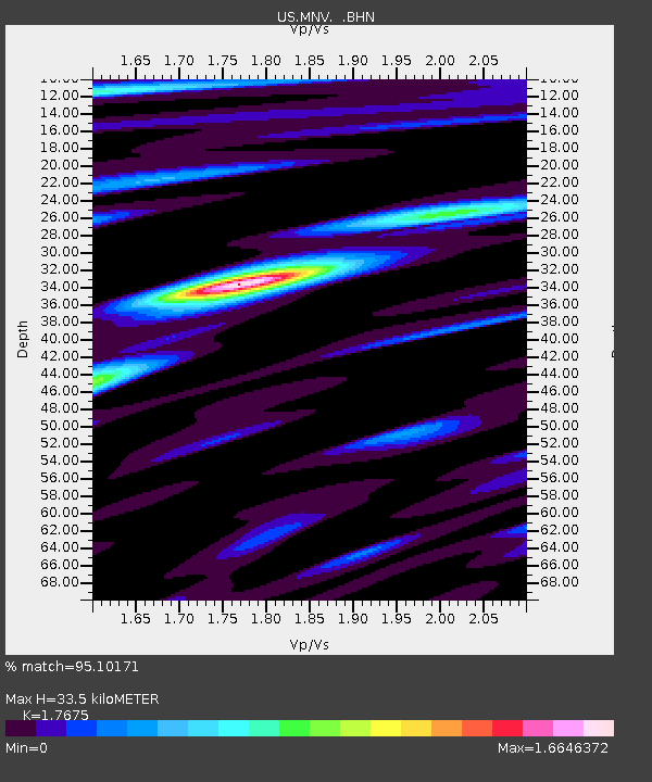
| Estimated Moho Depth: |
33.5 km |
| Estimated Crust Vp/Vs: |
1.77 |
| Assumed Crust Vp: |
6.279 km/s |
| Estimated Crust Vs: |
3.552 km/s |
| Estimated Crust Poisson's Ratio: |
0.26 |
|
| Radial Match: |
95.10171 % |
| Radial Bump: |
400 |
| Transverse Match: |
89.99736 % |
| Transverse Bump: |
400 |
| SOD ConfigId: |
110194 |
| Insert Time: |
2010-03-05 06:48:30.354 +0000 |
| GWidth: |
2.5 |
| Max Bumps: |
400 |
| Tol: |
0.001 |
|
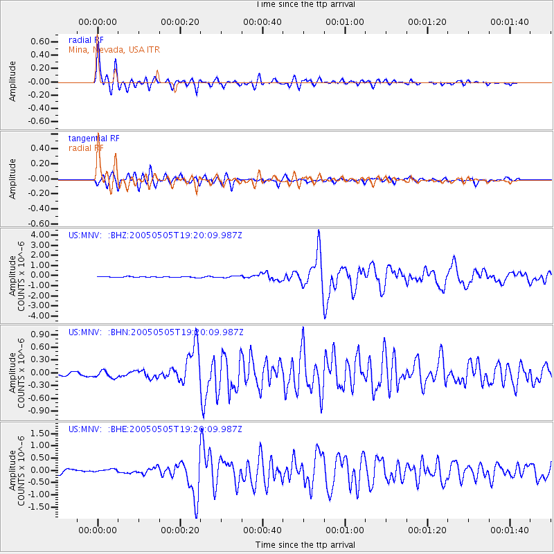
Signal To Noise
| Channel | StoN | STA | LTA |
| US:MNV: :BHN:20050505T19:20:09.987Z | 1.8761139 | 9.2708575E-8 | 4.9415217E-8 |
| US:MNV: :BHE:20050505T19:20:09.987Z | 1.3350055 | 1.02556136E-7 | 7.682076E-8 |
| US:MNV: :BHZ:20050505T19:20:09.987Z | 2.1965263 | 8.710688E-8 | 3.9656655E-8 |
| Arrivals |
| Ps | 4.4 SECOND |
| PpPs | 14 SECOND |
| PsPs/PpSs | 18 SECOND |


