You are here: Home > Network List > CN - Canadian National Seismograph Network Stations List
> Station INK INUVIK, NT > Earthquake Result Viewer
INK INUVIK, NT - Earthquake Result Viewer
*The percent match for this event was below the threshold and hence no stack was calculated.
| Earthquake location: |
Northern Mid-Atlantic Ridge |
| Earthquake latitude/longitude: |
22.1/-45.9 |
| Earthquake time(UTC): |
2016/09/09 (253) 17:17:54 GMT |
| Earthquake Depth: |
10 km |
| Earthquake Magnitude: |
5.5 MB |
| Earthquake Catalog/Contributor: |
NEIC PDE/NEIC COMCAT |
|
| Network: |
CN Canadian National Seismograph Network |
| Station: |
INK INUVIK, NT |
| Lat/Lon: |
68.31 N/133.53 W |
| Elevation: |
44 m |
|
| Distance: |
68.8 deg |
| Az: |
336.521 deg |
| Baz: |
83.589 deg |
| Ray Param: |
$rayparam |
*The percent match for this event was below the threshold and hence was not used in the summary stack. |
|
| Radial Match: |
50.487457 % |
| Radial Bump: |
400 |
| Transverse Match: |
43.801453 % |
| Transverse Bump: |
400 |
| SOD ConfigId: |
11737051 |
| Insert Time: |
2019-04-25 11:41:14.038 +0000 |
| GWidth: |
2.5 |
| Max Bumps: |
400 |
| Tol: |
0.001 |
|
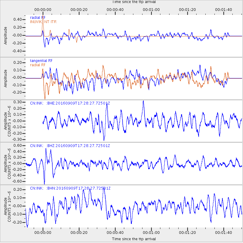
Signal To Noise
| Channel | StoN | STA | LTA |
| CN:INK: :BHZ:20160909T17:28:27.72501Z | 3.4254353 | 2.8662595E-7 | 8.367577E-8 |
| CN:INK: :BHN:20160909T17:28:27.72501Z | 1.0791633 | 9.407433E-8 | 8.717339E-8 |
| CN:INK: :BHE:20160909T17:28:27.72501Z | 2.40203 | 1.3757409E-7 | 5.7274097E-8 |
| Arrivals |
| Ps | |
| PpPs | |
| PsPs/PpSs | |


