You are here: Home > Network List > US - United States National Seismic Network Stations List
> Station MNV Mina, Nevada, USA > Earthquake Result Viewer
MNV Mina, Nevada, USA - Earthquake Result Viewer
| Earthquake location: |
Northern Chile |
| Earthquake latitude/longitude: |
-20.0/-69.2 |
| Earthquake time(UTC): |
2005/06/13 (164) 22:44:33 GMT |
| Earthquake Depth: |
116 km |
| Earthquake Magnitude: |
6.8 MB, 7.8 MW, 7.8 MW |
| Earthquake Catalog/Contributor: |
WHDF/NEIC |
|
| Network: |
US United States National Seismic Network |
| Station: |
MNV Mina, Nevada, USA |
| Lat/Lon: |
38.43 N/118.15 W |
| Elevation: |
1524 m |
|
| Distance: |
74.1 deg |
| Az: |
321.974 deg |
| Baz: |
132.463 deg |
| Ray Param: |
0.05230508 |
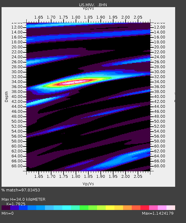
| Estimated Moho Depth: |
34.0 km |
| Estimated Crust Vp/Vs: |
1.79 |
| Assumed Crust Vp: |
6.279 km/s |
| Estimated Crust Vs: |
3.503 km/s |
| Estimated Crust Poisson's Ratio: |
0.27 |
|
| Radial Match: |
97.83453 % |
| Radial Bump: |
399 |
| Transverse Match: |
90.564896 % |
| Transverse Bump: |
400 |
| SOD ConfigId: |
110194 |
| Insert Time: |
2010-03-05 06:48:33.303 +0000 |
| GWidth: |
2.5 |
| Max Bumps: |
400 |
| Tol: |
0.001 |
|
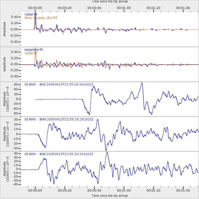
Signal To Noise
| Channel | StoN | STA | LTA |
| US:MNV: :BHN:20050613T22:55:26.261023Z | 20.614119 | 7.601338E-6 | 3.6874425E-7 |
| US:MNV: :BHE:20050613T22:55:26.261023Z | 34.369934 | 8.349674E-6 | 2.429354E-7 |
| US:MNV: :BHZ:20050613T22:55:26.261023Z | 45.763767 | 3.0410536E-5 | 6.6451116E-7 |
| Arrivals |
| Ps | 4.4 SECOND |
| PpPs | 15 SECOND |
| PsPs/PpSs | 19 SECOND |


