You are here: Home > Network List > US - United States National Seismic Network Stations List
> Station MNV Mina, Nevada, USA > Earthquake Result Viewer
MNV Mina, Nevada, USA - Earthquake Result Viewer
| Earthquake location: |
Panama-Costa Rica Border Region |
| Earthquake latitude/longitude: |
8.4/-82.9 |
| Earthquake time(UTC): |
2005/06/30 (181) 21:26:36 GMT |
| Earthquake Depth: |
38 km |
| Earthquake Magnitude: |
5.3 MB, 5.6 MS, 6.0 MW, 5.8 MW |
| Earthquake Catalog/Contributor: |
WHDF/NEIC |
|
| Network: |
US United States National Seismic Network |
| Station: |
MNV Mina, Nevada, USA |
| Lat/Lon: |
38.43 N/118.15 W |
| Elevation: |
1524 m |
|
| Distance: |
43.6 deg |
| Az: |
318.838 deg |
| Baz: |
123.994 deg |
| Ray Param: |
0.07238489 |
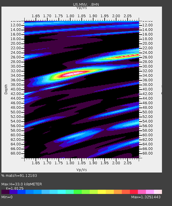
| Estimated Moho Depth: |
33.0 km |
| Estimated Crust Vp/Vs: |
1.81 |
| Assumed Crust Vp: |
6.279 km/s |
| Estimated Crust Vs: |
3.464 km/s |
| Estimated Crust Poisson's Ratio: |
0.28 |
|
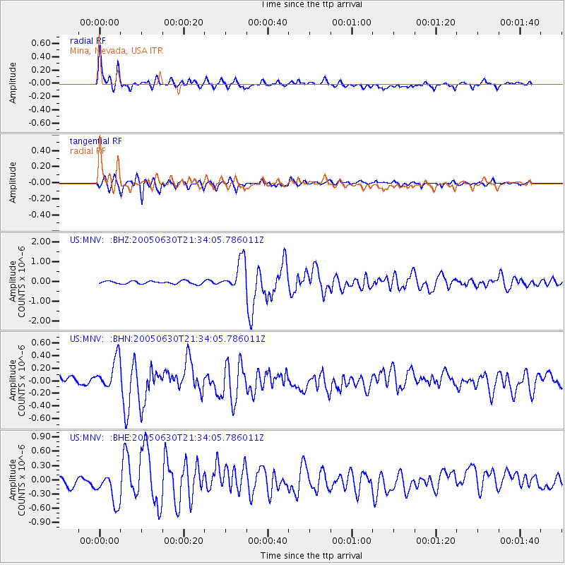
| Radial Match: |
91.12183 % |
| Radial Bump: |
400 |
| Transverse Match: |
86.593445 % |
| Transverse Bump: |
400 |
| SOD ConfigId: |
110194 |
| Insert Time: |
2010-03-05 06:48:35.210 +0000 |
| GWidth: |
2.5 |
| Max Bumps: |
400 |
| Tol: |
0.001 |
|
Signal To Noise
| Channel | StoN | STA | LTA |
| US:MNV: :BHN:20050630T21:34:05.786011Z | 4.4967556 | 2.552404E-7 | 5.6761007E-8 |
| US:MNV: :BHE:20050630T21:34:05.786011Z | 3.7503364 | 3.2930961E-7 | 8.780802E-8 |
| US:MNV: :BHZ:20050630T21:34:05.786011Z | 11.213152 | 8.10675E-7 | 7.229679E-8 |
| Arrivals |
| Ps | 4.5 SECOND |
| PpPs | 14 SECOND |
| PsPs/PpSs | 18 SECOND |


