You are here: Home > Network List > US - United States National Seismic Network Stations List
> Station MNV Mina, Nevada, USA > Earthquake Result Viewer
MNV Mina, Nevada, USA - Earthquake Result Viewer
| Earthquake location: |
W. Caroline Islands, Micronesia |
| Earthquake latitude/longitude: |
10.9/140.8 |
| Earthquake time(UTC): |
2005/01/16 (016) 20:17:52 GMT |
| Earthquake Depth: |
25 km |
| Earthquake Magnitude: |
6.3 MB, 6.7 MS, 6.6 MW, 6.6 MW |
| Earthquake Catalog/Contributor: |
WHDF/NEIC |
|
| Network: |
US United States National Seismic Network |
| Station: |
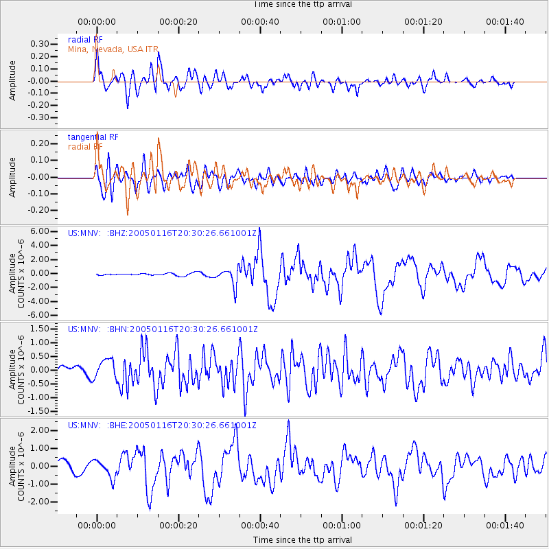
MNV Mina, Nevada, USA |
| Lat/Lon: |
38.43 N/118.15 W |
| Elevation: |
1524 m |
|
| Distance: |
91.8 deg |
| Az: |
50.469 deg |
| Baz: |
285.318 deg |
| Ray Param: |
0.041556846 |
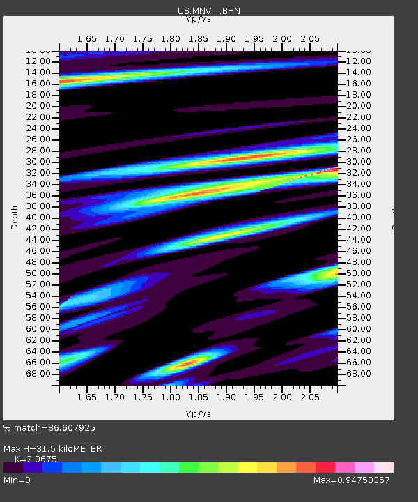
| Estimated Moho Depth: |
31.5 km |
| Estimated Crust Vp/Vs: |
2.07 |
| Assumed Crust Vp: |
6.279 km/s |
| Estimated Crust Vs: |
3.037 km/s |
| Estimated Crust Poisson's Ratio: |
0.35 |
|
| Radial Match: |
86.607925 % |
| Radial Bump: |
400 |
| Transverse Match: |
79.12592 % |
| Transverse Bump: |
400 |
| SOD ConfigId: |
110177 |
| Insert Time: |
2010-03-05 06:48:40.676 +0000 |
| GWidth: |
2.5 |
| Max Bumps: |
400 |
| Tol: |
0.001 |
|
Signal To Noise
| Channel | StoN | STA | LTA |
| US:MNV: :BHN:20050116T20:30:26.661001Z | 1.5593557 | 3.6003863E-7 | 2.3088934E-7 |
| US:MNV: :BHE:20050116T20:30:26.661001Z | 1.6998703 | 5.0725953E-7 | 2.984107E-7 |
| US:MNV: :BHZ:20050116T20:30:26.661001Z | 7.7911773 | 1.2740705E-6 | 1.6352735E-7 |
| Arrivals |
| Ps | 5.4 SECOND |
| PpPs | 15 SECOND |
| PsPs/PpSs | 21 SECOND |


