You are here: Home > Network List > US - United States National Seismic Network Stations List
> Station MNV Mina, Nevada, USA > Earthquake Result Viewer
MNV Mina, Nevada, USA - Earthquake Result Viewer
| Earthquake location: |
Solomon Islands |
| Earthquake latitude/longitude: |
-7.7/159.5 |
| Earthquake time(UTC): |
2005/01/22 (022) 20:30:17 GMT |
| Earthquake Depth: |
29 km |
| Earthquake Magnitude: |
6.2 MB, 6.5 MS, 6.4 MW, 6.4 MW |
| Earthquake Catalog/Contributor: |
WHDF/NEIC |
|
| Network: |
US United States National Seismic Network |
| Station: |
MNV Mina, Nevada, USA |
| Lat/Lon: |
38.43 N/118.15 W |
| Elevation: |
1524 m |
|
| Distance: |
88.8 deg |
| Az: |
51.131 deg |
| Baz: |
259.259 deg |
| Ray Param: |
0.042268746 |
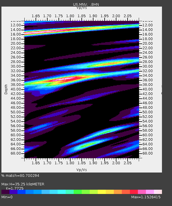
| Estimated Moho Depth: |
35.25 km |
| Estimated Crust Vp/Vs: |
1.77 |
| Assumed Crust Vp: |
6.279 km/s |
| Estimated Crust Vs: |
3.542 km/s |
| Estimated Crust Poisson's Ratio: |
0.27 |
|
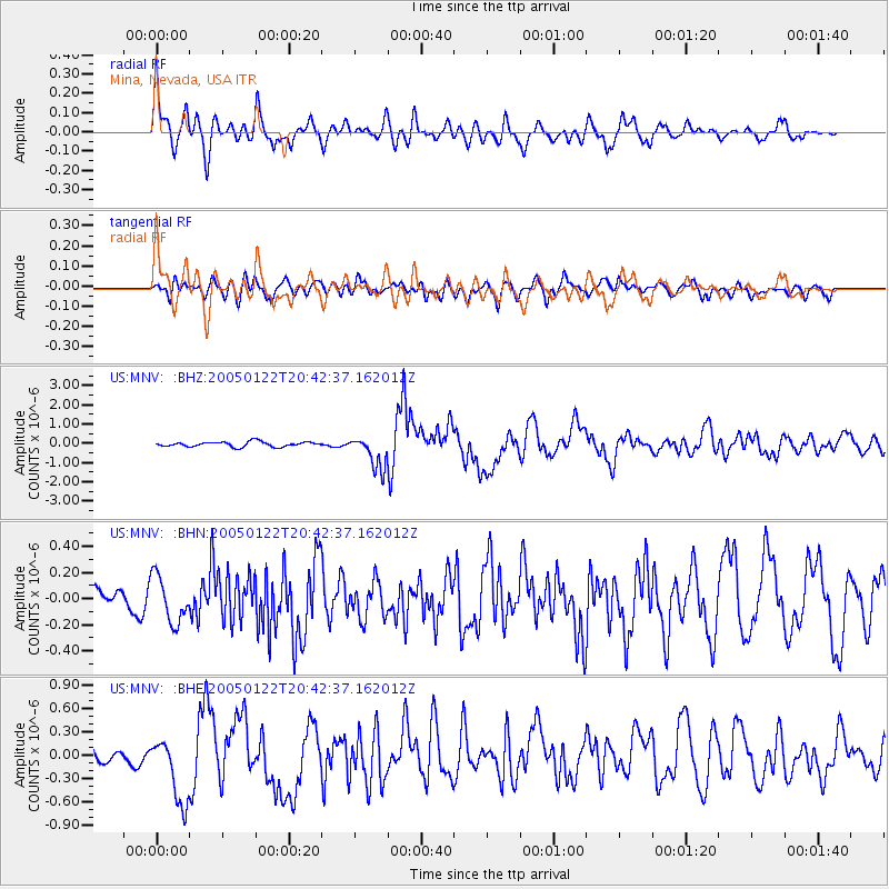
| Radial Match: |
80.700294 % |
| Radial Bump: |
400 |
| Transverse Match: |
57.60418 % |
| Transverse Bump: |
400 |
| SOD ConfigId: |
110177 |
| Insert Time: |
2010-03-05 06:48:44.636 +0000 |
| GWidth: |
2.5 |
| Max Bumps: |
400 |
| Tol: |
0.001 |
|
Signal To Noise
| Channel | StoN | STA | LTA |
| US:MNV: :BHN:20050122T20:42:37.162012Z | 2.1432674 | 1.7737622E-7 | 8.2759726E-8 |
| US:MNV: :BHE:20050122T20:42:37.162012Z | 2.1555464 | 4.6081544E-7 | 2.1378126E-7 |
| US:MNV: :BHZ:20050122T20:42:37.162012Z | 6.6376266 | 8.512248E-7 | 1.2824235E-7 |
| Arrivals |
| Ps | 4.4 SECOND |
| PpPs | 15 SECOND |
| PsPs/PpSs | 20 SECOND |


