You are here: Home > Network List > US - United States National Seismic Network Stations List
> Station MNV Mina, Nevada, USA > Earthquake Result Viewer
MNV Mina, Nevada, USA - Earthquake Result Viewer
| Earthquake location: |
New Britain Region, P.N.G. |
| Earthquake latitude/longitude: |
-4.8/152.5 |
| Earthquake time(UTC): |
1999/05/16 (136) 00:51:20 GMT |
| Earthquake Depth: |
74 km |
| Earthquake Magnitude: |
6.0 MB, 7.0 MS, 7.1 MW, 6.3 ME |
| Earthquake Catalog/Contributor: |
WHDF/NEIC |
|
| Network: |
US United States National Seismic Network |
| Station: |
MNV Mina, Nevada, USA |
| Lat/Lon: |
38.43 N/118.15 W |
| Elevation: |
1524 m |
|
| Distance: |
92.4 deg |
| Az: |
51.815 deg |
| Baz: |
265.896 deg |
| Ray Param: |
0.041425593 |
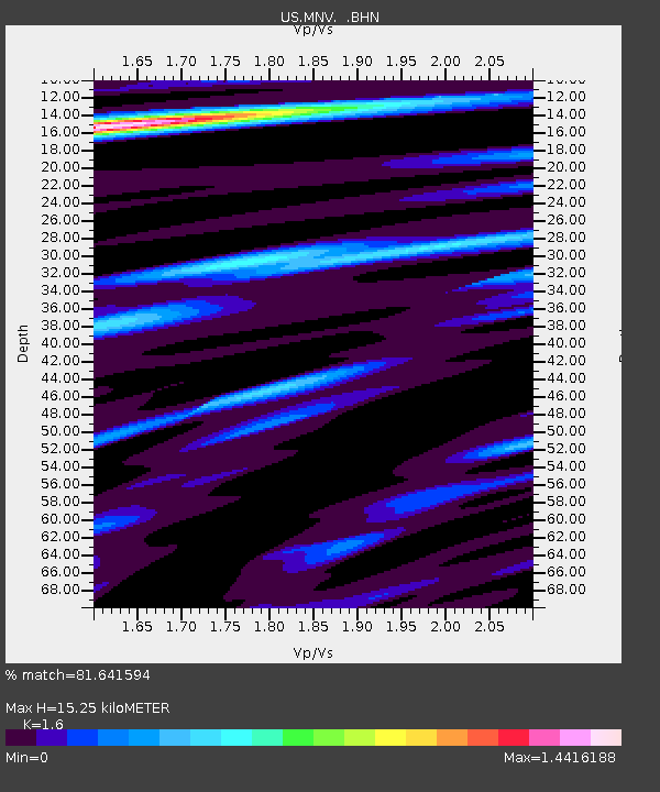
| Estimated Moho Depth: |
15.25 km |
| Estimated Crust Vp/Vs: |
1.60 |
| Assumed Crust Vp: |
6.279 km/s |
| Estimated Crust Vs: |
3.924 km/s |
| Estimated Crust Poisson's Ratio: |
0.18 |
|
| Radial Match: |
81.641594 % |
| Radial Bump: |
400 |
| Transverse Match: |
66.20137 % |
| Transverse Bump: |
400 |
| SOD ConfigId: |
110177 |
| Insert Time: |
2010-03-05 06:48:48.759 +0000 |
| GWidth: |
2.5 |
| Max Bumps: |
400 |
| Tol: |
0.001 |
|
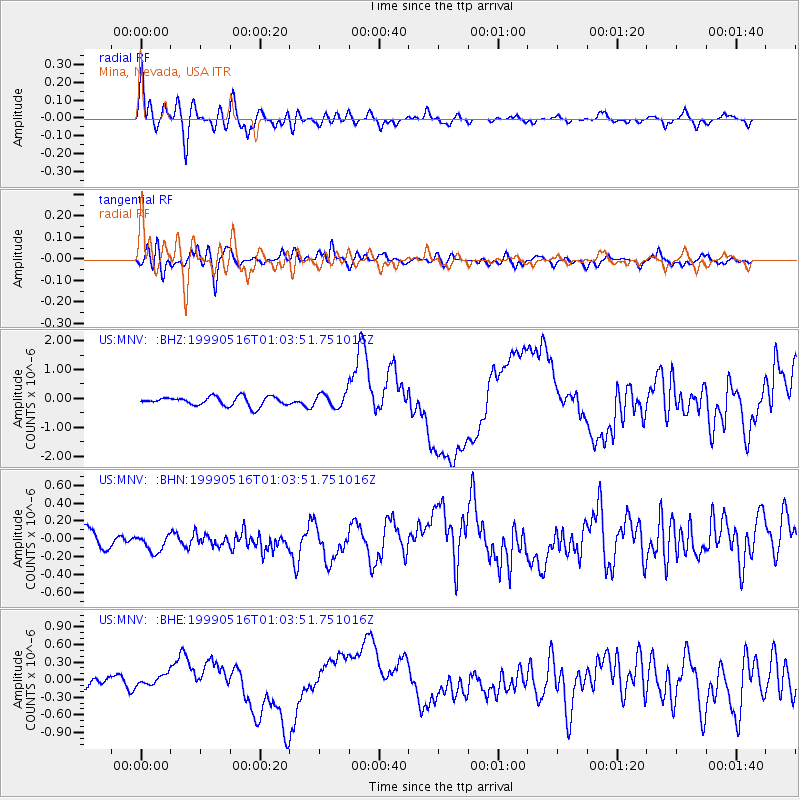
Signal To Noise
| Channel | StoN | STA | LTA |
| US:MNV: :BHN:19990516T01:03:51.751016Z | 1.523748 | 1.4873547E-7 | 9.761159E-8 |
| US:MNV: :BHE:19990516T01:03:51.751016Z | 0.45280856 | 8.557623E-8 | 1.8898987E-7 |
| US:MNV: :BHZ:19990516T01:03:51.751016Z | 1.5868809 | 2.5149328E-7 | 1.5848278E-7 |
| Arrivals |
| Ps | 1.5 SECOND |
| PpPs | 6.2 SECOND |
| PsPs/PpSs | 7.7 SECOND |


