You are here: Home > Network List > US - United States National Seismic Network Stations List
> Station MNV Mina, Nevada, USA > Earthquake Result Viewer
MNV Mina, Nevada, USA - Earthquake Result Viewer
| Earthquake location: |
South Of Fiji Islands |
| Earthquake latitude/longitude: |
-23.6/-180.0 |
| Earthquake time(UTC): |
2006/02/26 (057) 03:08:27 GMT |
| Earthquake Depth: |
535 km |
| Earthquake Magnitude: |
5.9 MB, 6.4 MW, 6.4 MW |
| Earthquake Catalog/Contributor: |
WHDF/NEIC |
|
| Network: |
US United States National Seismic Network |
| Station: |
MNV Mina, Nevada, USA |
| Lat/Lon: |
38.43 N/118.15 W |
| Elevation: |
1524 m |
|
| Distance: |
84.6 deg |
| Az: |
44.061 deg |
| Baz: |
234.316 deg |
| Ray Param: |
0.043814488 |
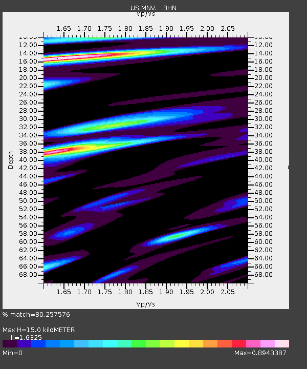
| Estimated Moho Depth: |
15.0 km |
| Estimated Crust Vp/Vs: |
1.63 |
| Assumed Crust Vp: |
6.279 km/s |
| Estimated Crust Vs: |
3.846 km/s |
| Estimated Crust Poisson's Ratio: |
0.20 |
|
| Radial Match: |
80.257576 % |
| Radial Bump: |
400 |
| Transverse Match: |
75.72655 % |
| Transverse Bump: |
400 |
| SOD ConfigId: |
2422 |
| Insert Time: |
2010-03-05 06:48:55.552 +0000 |
| GWidth: |
2.5 |
| Max Bumps: |
400 |
| Tol: |
0.001 |
|

Signal To Noise
| Channel | StoN | STA | LTA |
| US:MNV: :BHN:20060226T03:19:33.679019Z | 4.815146 | 5.7336126E-7 | 1.19074535E-7 |
| US:MNV: :BHE:20060226T03:19:33.679019Z | 6.669152 | 6.501599E-7 | 9.7487636E-8 |
| US:MNV: :BHZ:20060226T03:19:33.679019Z | 22.130539 | 3.346553E-6 | 1.5121877E-7 |
| Arrivals |
| Ps | 1.5 SECOND |
| PpPs | 6.1 SECOND |
| PsPs/PpSs | 7.7 SECOND |


