You are here: Home > Network List > US - United States National Seismic Network Stations List
> Station MNV Mina, Nevada, USA > Earthquake Result Viewer
MNV Mina, Nevada, USA - Earthquake Result Viewer
| Earthquake location: |
Off Coast Of Chiapas, Mexico |
| Earthquake latitude/longitude: |
15.0/-94.2 |
| Earthquake time(UTC): |
2006/06/27 (178) 13:03:12 GMT |
| Earthquake Depth: |
29 km |
| Earthquake Magnitude: |
5.4 MB, 5.5 MS, 5.8 MW, 5.8 MW |
| Earthquake Catalog/Contributor: |
WHDF/NEIC |
|
| Network: |
US United States National Seismic Network |
| Station: |
MNV Mina, Nevada, USA |
| Lat/Lon: |
38.43 N/118.15 W |
| Elevation: |
1524 m |
|
| Distance: |
31.5 deg |
| Az: |
322.391 deg |
| Baz: |
131.319 deg |
| Ray Param: |
0.07899921 |
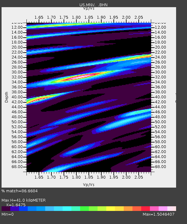
| Estimated Moho Depth: |
41.0 km |
| Estimated Crust Vp/Vs: |
1.65 |
| Assumed Crust Vp: |
6.279 km/s |
| Estimated Crust Vs: |
3.811 km/s |
| Estimated Crust Poisson's Ratio: |
0.21 |
|
| Radial Match: |
86.6684 % |
| Radial Bump: |
400 |
| Transverse Match: |
74.269936 % |
| Transverse Bump: |
400 |
| SOD ConfigId: |
2665 |
| Insert Time: |
2010-03-05 06:48:58.001 +0000 |
| GWidth: |
2.5 |
| Max Bumps: |
400 |
| Tol: |
0.001 |
|
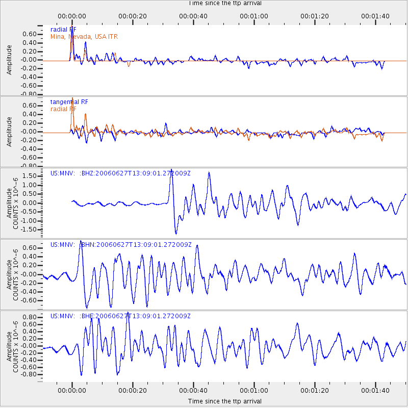
Signal To Noise
| Channel | StoN | STA | LTA |
| US:MNV: :BHN:20060627T13:09:01.272009Z | 3.8207254 | 3.9703443E-7 | 1.0391598E-7 |
| US:MNV: :BHE:20060627T13:09:01.272009Z | 3.387498 | 3.661209E-7 | 1.0808004E-7 |
| US:MNV: :BHZ:20060627T13:09:01.272009Z | 12.440899 | 9.598077E-7 | 7.714939E-8 |
| Arrivals |
| Ps | 4.6 SECOND |
| PpPs | 16 SECOND |
| PsPs/PpSs | 21 SECOND |


