You are here: Home > Network List > US - United States National Seismic Network Stations List
> Station MNV Mina, Nevada, USA > Earthquake Result Viewer
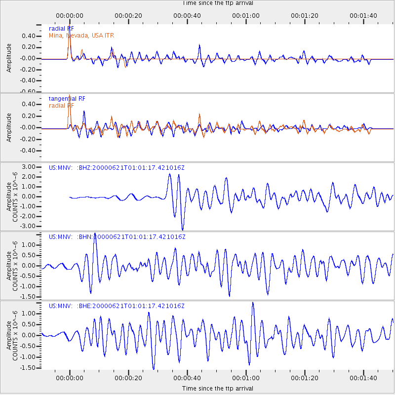
MNV Mina, Nevada, USA - Earthquake Result Viewer
| Earthquake location: |
Iceland |
| Earthquake latitude/longitude: |
64.0/-20.8 |
| Earthquake time(UTC): |
2000/06/21 (173) 00:51:46 GMT |
| Earthquake Depth: |
10 km |
| Earthquake Magnitude: |
6.1 MB, 6.6 MS, 6.5 MW, 6.4 MW |
| Earthquake Catalog/Contributor: |
WHDF/NEIC |
|
| Network: |
US United States National Seismic Network |
| Station: |
MNV Mina, Nevada, USA |
| Lat/Lon: |
38.43 N/118.15 W |
| Elevation: |
1524 m |
|
| Distance: |
59.3 deg |
| Az: |
295.035 deg |
| Baz: |
30.587 deg |
| Ray Param: |
0.06229905 |
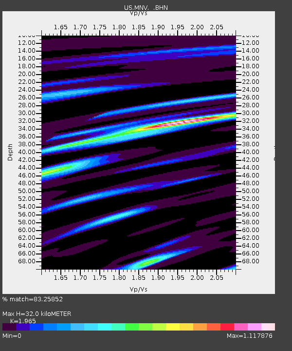
| Estimated Moho Depth: |
32.0 km |
| Estimated Crust Vp/Vs: |
1.97 |
| Assumed Crust Vp: |
6.279 km/s |
| Estimated Crust Vs: |
3.195 km/s |
| Estimated Crust Poisson's Ratio: |
0.33 |
|
| Radial Match: |
83.25852 % |
| Radial Bump: |
366 |
| Transverse Match: |
77.72087 % |
| Transverse Bump: |
400 |
| SOD ConfigId: |
110165 |
| Insert Time: |
2010-03-05 06:49:14.756 +0000 |
| GWidth: |
2.5 |
| Max Bumps: |
400 |
| Tol: |
0.001 |
|
Signal To Noise
| Channel | StoN | STA | LTA |
| US:MNV: :BHN:20000621T01:01:17.421016Z | 3.2137413 | 2.8268E-7 | 8.795978E-8 |
| US:MNV: :BHE:20000621T01:01:17.421016Z | 2.3384848 | 2.7980315E-7 | 1.1965147E-7 |
| US:MNV: :BHZ:20000621T01:01:17.421016Z | 6.650529 | 9.768064E-7 | 1.4687649E-7 |
| Arrivals |
| Ps | 5.1 SECOND |
| PpPs | 15 SECOND |
| PsPs/PpSs | 20 SECOND |


