You are here: Home > Network List > US - United States National Seismic Network Stations List
> Station MNV Mina, Nevada, USA > Earthquake Result Viewer
MNV Mina, Nevada, USA - Earthquake Result Viewer
| Earthquake location: |
Near Coast Of Guatemala |
| Earthquake latitude/longitude: |
13.9/-90.8 |
| Earthquake time(UTC): |
1999/06/06 (157) 07:08:05 GMT |
| Earthquake Depth: |
33 km |
| Earthquake Magnitude: |
5.5 MB, 5.9 MS, 6.3 MW, 5.8 MD |
| Earthquake Catalog/Contributor: |
WHDF/NEIC |
|
| Network: |
US United States National Seismic Network |
| Station: |
MNV Mina, Nevada, USA |
| Lat/Lon: |
38.43 N/118.15 W |
| Elevation: |
1524 m |
|
| Distance: |
34.4 deg |
| Az: |
320.274 deg |
| Baz: |
127.789 deg |
| Ray Param: |
0.077692956 |
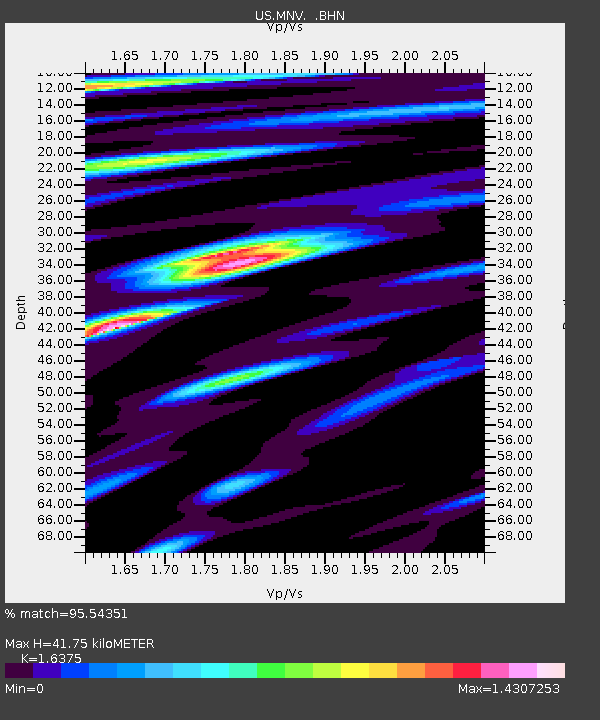
| Estimated Moho Depth: |
41.75 km |
| Estimated Crust Vp/Vs: |
1.64 |
| Assumed Crust Vp: |
6.279 km/s |
| Estimated Crust Vs: |
3.834 km/s |
| Estimated Crust Poisson's Ratio: |
0.20 |
|
| Radial Match: |
95.54351 % |
| Radial Bump: |
327 |
| Transverse Match: |
90.30852 % |
| Transverse Bump: |
400 |
| SOD ConfigId: |
110177 |
| Insert Time: |
2010-03-05 06:49:19.829 +0000 |
| GWidth: |
2.5 |
| Max Bumps: |
400 |
| Tol: |
0.001 |
|
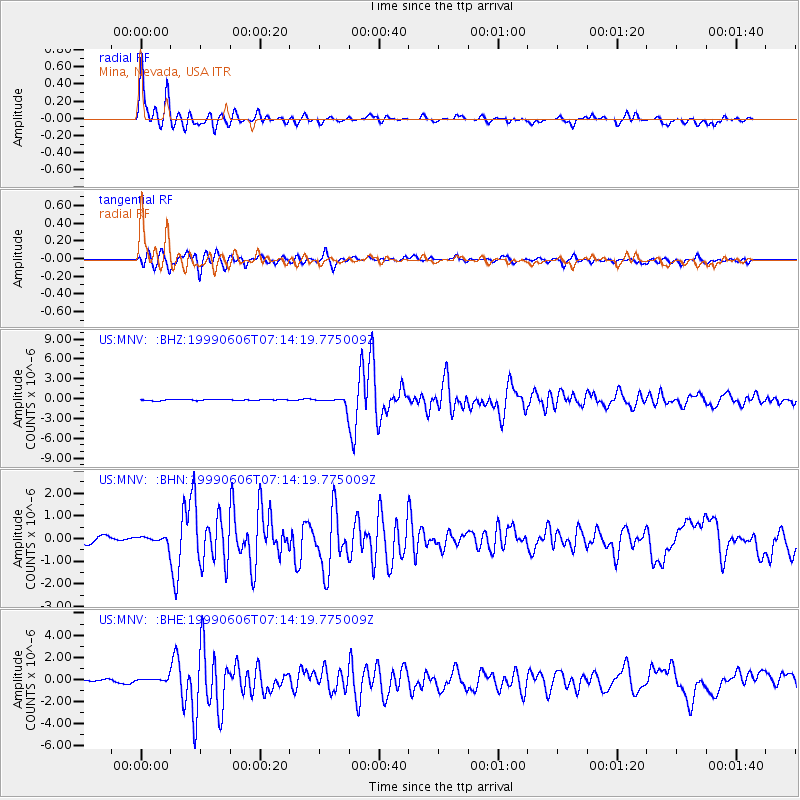
Signal To Noise
| Channel | StoN | STA | LTA |
| US:MNV: :BHN:19990606T07:14:19.775009Z | 1.3455472 | 1.8488242E-7 | 1.3740315E-7 |
| US:MNV: :BHE:19990606T07:14:19.775009Z | 2.3421874 | 1.9697266E-7 | 8.409774E-8 |
| US:MNV: :BHZ:19990606T07:14:19.775009Z | 8.5097275 | 7.1756256E-7 | 8.432263E-8 |
| Arrivals |
| Ps | 4.6 SECOND |
| PpPs | 16 SECOND |
| PsPs/PpSs | 21 SECOND |


