You are here: Home > Network List > US - United States National Seismic Network Stations List
> Station MNV Mina, Nevada, USA > Earthquake Result Viewer
MNV Mina, Nevada, USA - Earthquake Result Viewer
| Earthquake location: |
Hokkaido, Japan Region |
| Earthquake latitude/longitude: |
41.0/142.3 |
| Earthquake time(UTC): |
2001/08/13 (225) 20:11:23 GMT |
| Earthquake Depth: |
38 km |
| Earthquake Magnitude: |
6.0 MB, 6.3 MS, 6.4 MW, 6.3 ME |
| Earthquake Catalog/Contributor: |
WHDF/NEIC |
|
| Network: |
US United States National Seismic Network |
| Station: |
MNV Mina, Nevada, USA |
| Lat/Lon: |
38.43 N/118.15 W |
| Elevation: |
1524 m |
|
| Distance: |
72.2 deg |
| Az: |
54.456 deg |
| Baz: |
308.407 deg |
| Ray Param: |
0.053788893 |
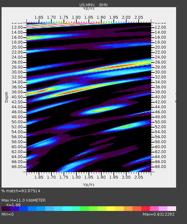
| Estimated Moho Depth: |
11.0 km |
| Estimated Crust Vp/Vs: |
1.69 |
| Assumed Crust Vp: |
6.279 km/s |
| Estimated Crust Vs: |
3.715 km/s |
| Estimated Crust Poisson's Ratio: |
0.23 |
|
| Radial Match: |
93.97514 % |
| Radial Bump: |
400 |
| Transverse Match: |
91.36951 % |
| Transverse Bump: |
400 |
| SOD ConfigId: |
110165 |
| Insert Time: |
2010-03-05 06:49:24.309 +0000 |
| GWidth: |
2.5 |
| Max Bumps: |
400 |
| Tol: |
0.001 |
|
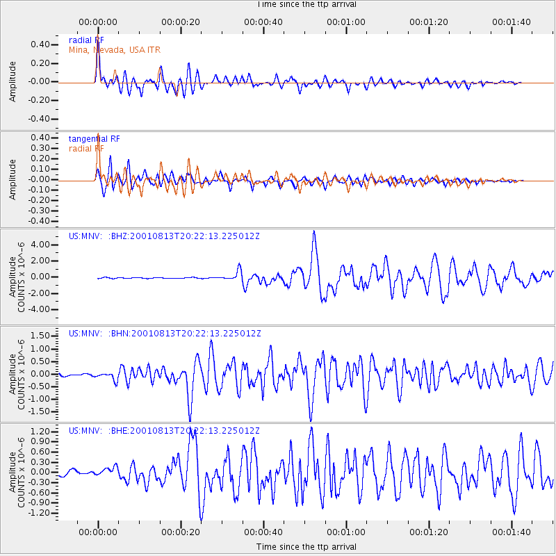
Signal To Noise
| Channel | StoN | STA | LTA |
| US:MNV: :BHN:20010813T20:22:13.225012Z | 2.9512336 | 1.4490455E-7 | 4.9099654E-8 |
| US:MNV: :BHE:20010813T20:22:13.225012Z | 2.2945883 | 1.381992E-7 | 6.022832E-8 |
| US:MNV: :BHZ:20010813T20:22:13.225012Z | 12.104612 | 6.2037793E-7 | 5.125137E-8 |
| Arrivals |
| Ps | 1.3 SECOND |
| PpPs | 4.6 SECOND |
| PsPs/PpSs | 5.8 SECOND |


