You are here: Home > Network List > US - United States National Seismic Network Stations List
> Station MNV Mina, Nevada, USA > Earthquake Result Viewer
MNV Mina, Nevada, USA - Earthquake Result Viewer
| Earthquake location: |
Near Coast Of Peru |
| Earthquake latitude/longitude: |
-17.7/-71.6 |
| Earthquake time(UTC): |
2001/06/26 (177) 04:18:31 GMT |
| Earthquake Depth: |
24 km |
| Earthquake Magnitude: |
6.2 MB, 6.7 MS, 6.8 MW, 6.7 ME |
| Earthquake Catalog/Contributor: |
WHDF/NEIC |
|
| Network: |
US United States National Seismic Network |
| Station: |
MNV Mina, Nevada, USA |
| Lat/Lon: |
38.43 N/118.15 W |
| Elevation: |
1524 m |
|
| Distance: |
70.9 deg |
| Az: |
322.914 deg |
| Baz: |
132.968 deg |
| Ray Param: |
0.054664705 |
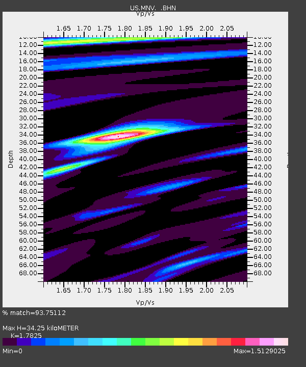
| Estimated Moho Depth: |
34.25 km |
| Estimated Crust Vp/Vs: |
1.78 |
| Assumed Crust Vp: |
6.279 km/s |
| Estimated Crust Vs: |
3.522 km/s |
| Estimated Crust Poisson's Ratio: |
0.27 |
|
| Radial Match: |
93.75112 % |
| Radial Bump: |
400 |
| Transverse Match: |
88.23238 % |
| Transverse Bump: |
400 |
| SOD ConfigId: |
110165 |
| Insert Time: |
2010-03-05 06:49:26.706 +0000 |
| GWidth: |
2.5 |
| Max Bumps: |
400 |
| Tol: |
0.001 |
|
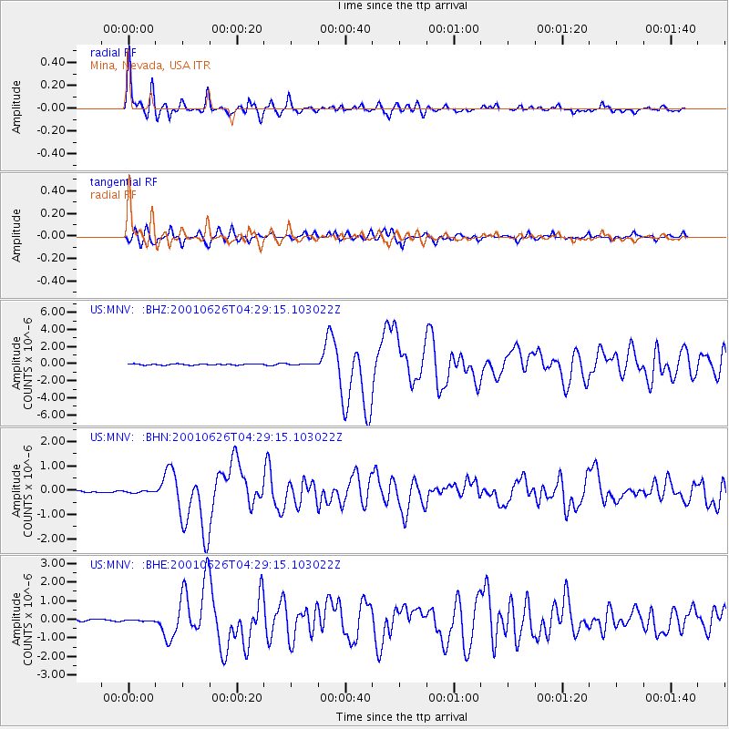
Signal To Noise
| Channel | StoN | STA | LTA |
| US:MNV: :BHN:20010626T04:29:15.103022Z | 0.9538042 | 3.9205403E-8 | 4.110425E-8 |
| US:MNV: :BHE:20010626T04:29:15.103022Z | 0.34034702 | 2.8978029E-8 | 8.5142595E-8 |
| US:MNV: :BHZ:20010626T04:29:15.103022Z | 1.1096712 | 7.068788E-8 | 6.370165E-8 |
| Arrivals |
| Ps | 4.4 SECOND |
| PpPs | 15 SECOND |
| PsPs/PpSs | 19 SECOND |


