You are here: Home > Network List > US - United States National Seismic Network Stations List
> Station MNV Mina, Nevada, USA > Earthquake Result Viewer
MNV Mina, Nevada, USA - Earthquake Result Viewer
| Earthquake location: |
Kermadec Islands, New Zealand |
| Earthquake latitude/longitude: |
-29.7/-178.6 |
| Earthquake time(UTC): |
2001/06/03 (154) 02:41:57 GMT |
| Earthquake Depth: |
178 km |
| Earthquake Magnitude: |
6.8 MB, 7.2 MW, 7.1 MW |
| Earthquake Catalog/Contributor: |
WHDF/NEIC |
|
| Network: |
US United States National Seismic Network |
| Station: |
MNV Mina, Nevada, USA |
| Lat/Lon: |
38.43 N/118.15 W |
| Elevation: |
1524 m |
|
| Distance: |
88.2 deg |
| Az: |
43.138 deg |
| Baz: |
229.266 deg |
| Ray Param: |
0.04237903 |
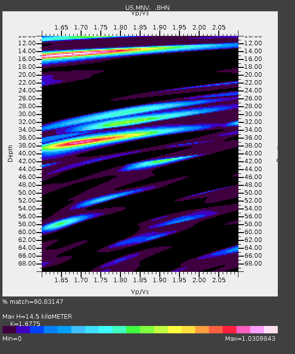
| Estimated Moho Depth: |
14.5 km |
| Estimated Crust Vp/Vs: |
1.68 |
| Assumed Crust Vp: |
6.279 km/s |
| Estimated Crust Vs: |
3.743 km/s |
| Estimated Crust Poisson's Ratio: |
0.22 |
|
| Radial Match: |
90.83147 % |
| Radial Bump: |
400 |
| Transverse Match: |
82.78108 % |
| Transverse Bump: |
400 |
| SOD ConfigId: |
110165 |
| Insert Time: |
2010-03-05 06:49:28.041 +0000 |
| GWidth: |
2.5 |
| Max Bumps: |
400 |
| Tol: |
0.001 |
|
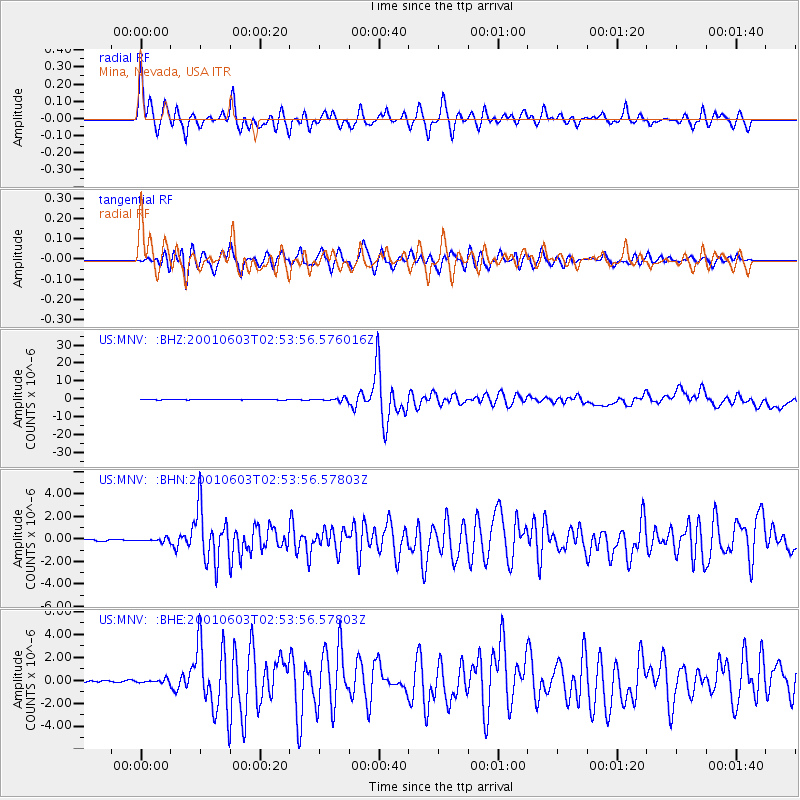
Signal To Noise
| Channel | StoN | STA | LTA |
| US:MNV: :BHN:20010603T02:53:56.57803Z | 2.2503088 | 1.4249456E-7 | 6.3322226E-8 |
| US:MNV: :BHE:20010603T02:53:56.57803Z | 1.6906236 | 1.5895759E-7 | 9.402305E-8 |
| US:MNV: :BHZ:20010603T02:53:56.576016Z | 16.137356 | 8.3422174E-7 | 5.169507E-8 |
| Arrivals |
| Ps | 1.6 SECOND |
| PpPs | 6.1 SECOND |
| PsPs/PpSs | 7.7 SECOND |


