You are here: Home > Network List > US - United States National Seismic Network Stations List
> Station MNV Mina, Nevada, USA > Earthquake Result Viewer
MNV Mina, Nevada, USA - Earthquake Result Viewer
| Earthquake location: |
Ecuador |
| Earthquake latitude/longitude: |
-1.3/-77.5 |
| Earthquake time(UTC): |
1999/08/28 (240) 12:40:06 GMT |
| Earthquake Depth: |
196 km |
| Earthquake Magnitude: |
5.9 MB, 6.3 MW, 6.2 MW |
| Earthquake Catalog/Contributor: |
WHDF/NEIC |
|
| Network: |
US United States National Seismic Network |
| Station: |
MNV Mina, Nevada, USA |
| Lat/Lon: |
38.43 N/118.15 W |
| Elevation: |
1524 m |
|
| Distance: |
54.4 deg |
| Az: |
321.043 deg |
| Baz: |
126.835 deg |
| Ray Param: |
0.06480351 |
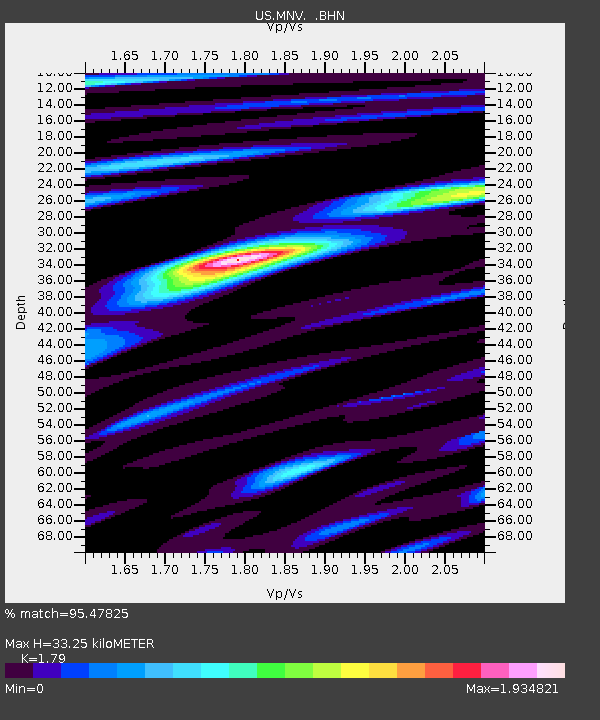
| Estimated Moho Depth: |
33.25 km |
| Estimated Crust Vp/Vs: |
1.79 |
| Assumed Crust Vp: |
6.279 km/s |
| Estimated Crust Vs: |
3.508 km/s |
| Estimated Crust Poisson's Ratio: |
0.27 |
|
| Radial Match: |
95.47825 % |
| Radial Bump: |
395 |
| Transverse Match: |
90.540016 % |
| Transverse Bump: |
367 |
| SOD ConfigId: |
110177 |
| Insert Time: |
2010-03-05 06:49:35.235 +0000 |
| GWidth: |
2.5 |
| Max Bumps: |
400 |
| Tol: |
0.001 |
|
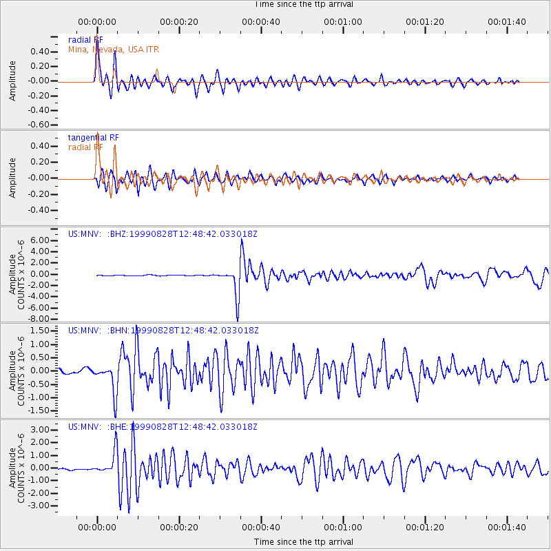
Signal To Noise
| Channel | StoN | STA | LTA |
| US:MNV: :BHN:19990828T12:48:42.033018Z | 10.074651 | 5.7408005E-7 | 5.6982625E-8 |
| US:MNV: :BHE:19990828T12:48:42.033018Z | 10.803956 | 9.391977E-7 | 8.693091E-8 |
| US:MNV: :BHZ:19990828T12:48:42.033018Z | 37.263355 | 2.613278E-6 | 7.0129964E-8 |
| Arrivals |
| Ps | 4.4 SECOND |
| PpPs | 14 SECOND |
| PsPs/PpSs | 18 SECOND |


