You are here: Home > Network List > US - United States National Seismic Network Stations List
> Station MNV Mina, Nevada, USA > Earthquake Result Viewer
MNV Mina, Nevada, USA - Earthquake Result Viewer
| Earthquake location: |
Costa Rica |
| Earthquake latitude/longitude: |
8.8/-84.0 |
| Earthquake time(UTC): |
2002/06/16 (167) 02:46:14 GMT |
| Earthquake Depth: |
35 km |
| Earthquake Magnitude: |
5.4 MB, 6.2 MS, 6.4 MW, 6.4 MW |
| Earthquake Catalog/Contributor: |
WHDF/NEIC |
|
| Network: |
US United States National Seismic Network |
| Station: |
MNV Mina, Nevada, USA |
| Lat/Lon: |
38.43 N/118.15 W |
| Elevation: |
1524 m |
|
| Distance: |
42.6 deg |
| Az: |
319.331 deg |
| Baz: |
124.897 deg |
| Ray Param: |
0.07301873 |
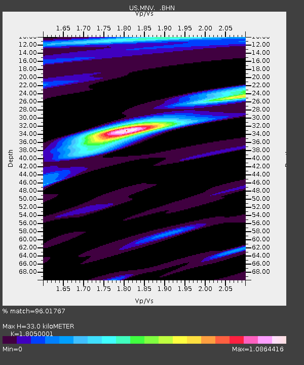
| Estimated Moho Depth: |
33.0 km |
| Estimated Crust Vp/Vs: |
1.81 |
| Assumed Crust Vp: |
6.279 km/s |
| Estimated Crust Vs: |
3.478 km/s |
| Estimated Crust Poisson's Ratio: |
0.28 |
|
| Radial Match: |
96.01767 % |
| Radial Bump: |
296 |
| Transverse Match: |
86.21937 % |
| Transverse Bump: |
400 |
| SOD ConfigId: |
110177 |
| Insert Time: |
2010-03-05 06:49:38.296 +0000 |
| GWidth: |
2.5 |
| Max Bumps: |
400 |
| Tol: |
0.001 |
|
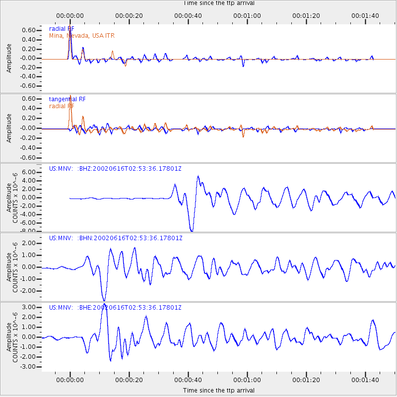
Signal To Noise
| Channel | StoN | STA | LTA |
| US:MNV: :BHN:20020616T02:53:36.17801Z | 2.265944 | 1.2770444E-7 | 5.635816E-8 |
| US:MNV: :BHE:20020616T02:53:36.17801Z | 1.3950753 | 1.2383684E-7 | 8.876714E-8 |
| US:MNV: :BHZ:20020616T02:53:36.17801Z | 4.7040157 | 3.7942038E-7 | 8.065883E-8 |
| Arrivals |
| Ps | 4.5 SECOND |
| PpPs | 14 SECOND |
| PsPs/PpSs | 18 SECOND |


