You are here: Home > Network List > US - United States National Seismic Network Stations List
> Station MNV Mina, Nevada, USA > Earthquake Result Viewer
MNV Mina, Nevada, USA - Earthquake Result Viewer
| Earthquake location: |
Near West Coast Of Colombia |
| Earthquake latitude/longitude: |
5.0/-77.8 |
| Earthquake time(UTC): |
2002/08/08 (220) 13:39:58 GMT |
| Earthquake Depth: |
43 km |
| Earthquake Magnitude: |
5.4 MB, 5.0 MS, 5.9 MW, 5.7 MW |
| Earthquake Catalog/Contributor: |
WHDF/NEIC |
|
| Network: |
US United States National Seismic Network |
| Station: |
MNV Mina, Nevada, USA |
| Lat/Lon: |
38.43 N/118.15 W |
| Elevation: |
1524 m |
|
| Distance: |
49.5 deg |
| Az: |
318.028 deg |
| Baz: |
121.966 deg |
| Ray Param: |
0.068578936 |
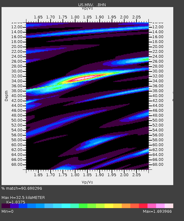
| Estimated Moho Depth: |
32.5 km |
| Estimated Crust Vp/Vs: |
1.84 |
| Assumed Crust Vp: |
6.279 km/s |
| Estimated Crust Vs: |
3.417 km/s |
| Estimated Crust Poisson's Ratio: |
0.29 |
|
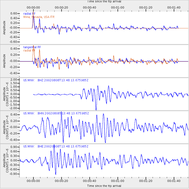
| Radial Match: |
90.698296 % |
| Radial Bump: |
400 |
| Transverse Match: |
89.39711 % |
| Transverse Bump: |
400 |
| SOD ConfigId: |
110177 |
| Insert Time: |
2010-03-05 06:49:46.809 +0000 |
| GWidth: |
2.5 |
| Max Bumps: |
400 |
| Tol: |
0.001 |
|
Signal To Noise
| Channel | StoN | STA | LTA |
| US:MNV: :BHN:20020808T13:48:13.675985Z | 1.2933445 | 8.135711E-8 | 6.2904434E-8 |
| US:MNV: :BHE:20020808T13:48:13.675985Z | 2.0979266 | 1.1133994E-7 | 5.307142E-8 |
| US:MNV: :BHZ:20020808T13:48:13.675985Z | 5.405267 | 2.0198488E-7 | 3.736816E-8 |
| Arrivals |
| Ps | 4.6 SECOND |
| PpPs | 14 SECOND |
| PsPs/PpSs | 18 SECOND |


