You are here: Home > Network List > US - United States National Seismic Network Stations List
> Station MNV Mina, Nevada, USA > Earthquake Result Viewer
MNV Mina, Nevada, USA - Earthquake Result Viewer

| Earthquake location: |
Southeast Of Honshu, Japan |
| Earthquake latitude/longitude: |
31.0/142.0 |
| Earthquake time(UTC): |
2002/08/20 (232) 10:59:32 GMT |
| Earthquake Depth: |
9.0 km |
| Earthquake Magnitude: |
5.4 MB, 6.2 MS, 6.3 MW, 6.1 MW |
| Earthquake Catalog/Contributor: |
WHDF/NEIC |
|
| Network: |
US United States National Seismic Network |
| Station: |
MNV Mina, Nevada, USA |
| Lat/Lon: |
38.43 N/118.15 W |
| Elevation: |
1524 m |
|
| Distance: |
78.4 deg |
| Az: |
52.176 deg |
| Baz: |
300.257 deg |
| Ray Param: |
0.049681373 |
| Estimated Moho Depth: |
15.75 km |
| Estimated Crust Vp/Vs: |
1.60 |
| Assumed Crust Vp: |
6.279 km/s |
| Estimated Crust Vs: |
3.924 km/s |
| Estimated Crust Poisson's Ratio: |
0.18 |
|
| Radial Match: |
84.50995 % |
| Radial Bump: |
400 |
| Transverse Match: |
76.74756 % |
| Transverse Bump: |
400 |
| SOD ConfigId: |
110177 |
| Insert Time: |
2010-03-05 06:49:48.555 +0000 |
| GWidth: |
2.5 |
| Max Bumps: |
400 |
| Tol: |
0.001 |
|
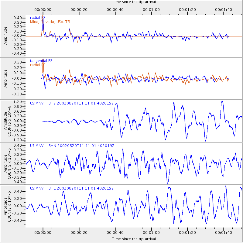
Signal To Noise
| Channel | StoN | STA | LTA |
| US:MNV: :BHN:20020820T11:11:01.402019Z | 0.6646373 | 4.3007148E-8 | 6.470769E-8 |
| US:MNV: :BHE:20020820T11:11:01.402019Z | 1.6126612 | 1.351975E-7 | 8.383503E-8 |
| US:MNV: :BHZ:20020820T11:11:01.402019Z | 1.3745521 | 9.110458E-8 | 6.627947E-8 |
| Arrivals |
| Ps | 1.6 SECOND |
| PpPs | 6.3 SECOND |
| PsPs/PpSs | 7.9 SECOND |


