You are here: Home > Network List > US - United States National Seismic Network Stations List
> Station MNV Mina, Nevada, USA > Earthquake Result Viewer
MNV Mina, Nevada, USA - Earthquake Result Viewer
| Earthquake location: |
Fiji Islands Region |
| Earthquake latitude/longitude: |
-21.0/-179.0 |
| Earthquake time(UTC): |
2002/10/04 (277) 19:05:48 GMT |
| Earthquake Depth: |
621 km |
| Earthquake Magnitude: |
6.1 MB, 6.3 MW, 6.3 MW |
| Earthquake Catalog/Contributor: |
WHDF/NEIC |
|
| Network: |
US United States National Seismic Network |
| Station: |
MNV Mina, Nevada, USA |
| Lat/Lon: |
38.43 N/118.15 W |
| Elevation: |
1524 m |
|
| Distance: |
82.1 deg |
| Az: |
43.828 deg |
| Baz: |
235.482 deg |
| Ray Param: |
0.045203216 |
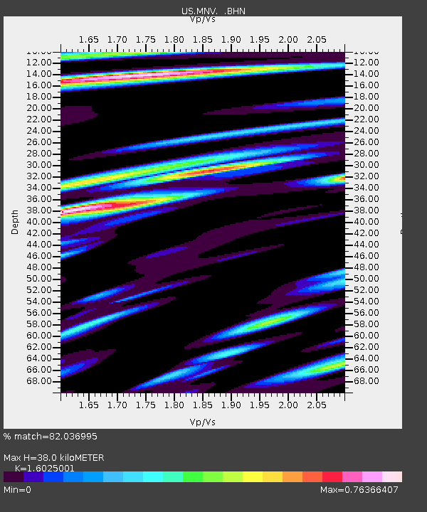
| Estimated Moho Depth: |
38.0 km |
| Estimated Crust Vp/Vs: |
1.60 |
| Assumed Crust Vp: |
6.279 km/s |
| Estimated Crust Vs: |
3.918 km/s |
| Estimated Crust Poisson's Ratio: |
0.18 |
|
| Radial Match: |
82.036995 % |
| Radial Bump: |
400 |
| Transverse Match: |
64.03141 % |
| Transverse Bump: |
400 |
| SOD ConfigId: |
110177 |
| Insert Time: |
2010-03-05 06:49:52.915 +0000 |
| GWidth: |
2.5 |
| Max Bumps: |
400 |
| Tol: |
0.001 |
|
Signal To Noise
| Channel | StoN | STA | LTA |
| US:MNV: :BHN:20021004T19:16:34.827007Z | 3.544569 | 3.068129E-7 | 8.655859E-8 |
| US:MNV: :BHE:20021004T19:16:34.827007Z | 3.0067692 | 3.624873E-7 | 1.2055708E-7 |
| US:MNV: :BHZ:20021004T19:16:34.827007Z | 20.563543 | 2.0009506E-6 | 9.730573E-8 |
| Arrivals |
| Ps | 3.7 SECOND |
| PpPs | 15 SECOND |
| PsPs/PpSs | 19 SECOND |


