You are here: Home > Network List > TA - USArray Transportable Network (new EarthScope stations) Stations List
> Station 435B Jarrell, TX, USA > Earthquake Result Viewer
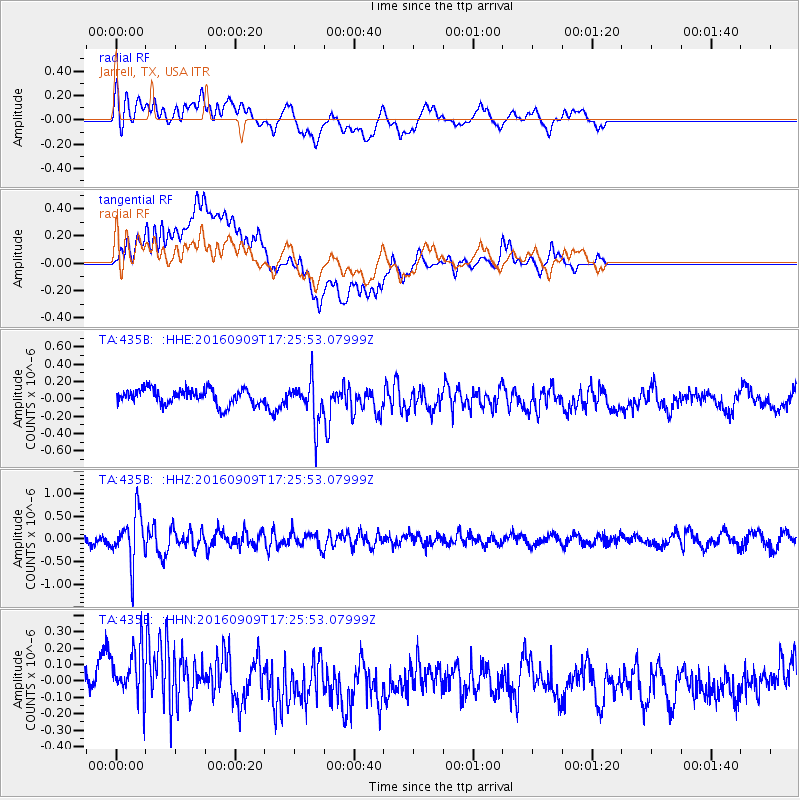
435B Jarrell, TX, USA - Earthquake Result Viewer
*The percent match for this event was below the threshold and hence no stack was calculated.
| Earthquake location: |
Northern Mid-Atlantic Ridge |
| Earthquake latitude/longitude: |
22.1/-45.9 |
| Earthquake time(UTC): |
2016/09/09 (253) 17:17:54 GMT |
| Earthquake Depth: |
10 km |
| Earthquake Magnitude: |
5.5 MB |
| Earthquake Catalog/Contributor: |
NEIC PDE/NEIC COMCAT |
|
| Network: |
TA USArray Transportable Network (new EarthScope stations) |
| Station: |
435B Jarrell, TX, USA |
| Lat/Lon: |
30.78 N/97.58 W |
| Elevation: |
248 m |
|
| Distance: |
46.8 deg |
| Az: |
291.984 deg |
| Baz: |
87.675 deg |
| Ray Param: |
$rayparam |
*The percent match for this event was below the threshold and hence was not used in the summary stack. |
|
| Radial Match: |
62.203857 % |
| Radial Bump: |
400 |
| Transverse Match: |
75.76098 % |
| Transverse Bump: |
400 |
| SOD ConfigId: |
11737051 |
| Insert Time: |
2019-04-25 11:47:19.278 +0000 |
| GWidth: |
2.5 |
| Max Bumps: |
400 |
| Tol: |
0.001 |
|
Signal To Noise
| Channel | StoN | STA | LTA |
| TA:435B: :HHZ:20160909T17:25:53.07999Z | 6.390288 | 5.4077765E-7 | 8.462493E-8 |
| TA:435B: :HHN:20160909T17:25:53.07999Z | 1.7282891 | 2.1958934E-7 | 1.2705591E-7 |
| TA:435B: :HHE:20160909T17:25:53.07999Z | 2.6698453 | 2.3909584E-7 | 8.955419E-8 |
| Arrivals |
| Ps | |
| PpPs | |
| PsPs/PpSs | |


