You are here: Home > Network List > TA - USArray Transportable Network (new EarthScope stations) Stations List
> Station D25K Kavik River, AK, USA > Earthquake Result Viewer
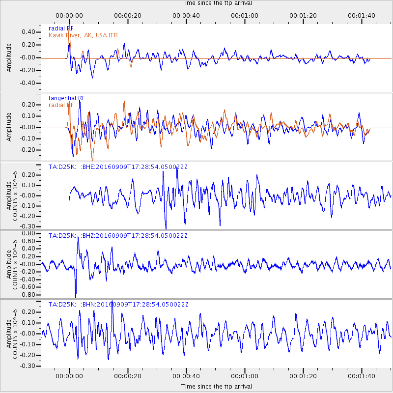
D25K Kavik River, AK, USA - Earthquake Result Viewer
*The percent match for this event was below the threshold and hence no stack was calculated.
| Earthquake location: |
Northern Mid-Atlantic Ridge |
| Earthquake latitude/longitude: |
22.1/-45.9 |
| Earthquake time(UTC): |
2016/09/09 (253) 17:17:54 GMT |
| Earthquake Depth: |
10 km |
| Earthquake Magnitude: |
5.5 MB |
| Earthquake Catalog/Contributor: |
NEIC PDE/NEIC COMCAT |
|
| Network: |
TA USArray Transportable Network (new EarthScope stations) |
| Station: |
D25K Kavik River, AK, USA |
| Lat/Lon: |
69.32 N/146.38 W |
| Elevation: |
770 m |
|
| Distance: |
73.2 deg |
| Az: |
338.6 deg |
| Baz: |
72.289 deg |
| Ray Param: |
$rayparam |
*The percent match for this event was below the threshold and hence was not used in the summary stack. |
|
| Radial Match: |
69.81364 % |
| Radial Bump: |
400 |
| Transverse Match: |
63.52908 % |
| Transverse Bump: |
400 |
| SOD ConfigId: |
11737051 |
| Insert Time: |
2019-04-25 11:47:24.649 +0000 |
| GWidth: |
2.5 |
| Max Bumps: |
400 |
| Tol: |
0.001 |
|
Signal To Noise
| Channel | StoN | STA | LTA |
| TA:D25K: :BHZ:20160909T17:28:54.050022Z | 3.6771145 | 3.1107547E-7 | 8.459771E-8 |
| TA:D25K: :BHN:20160909T17:28:54.050022Z | 2.3302631 | 1.00070274E-7 | 4.2943764E-8 |
| TA:D25K: :BHE:20160909T17:28:54.050022Z | 1.7644358 | 1.18006E-7 | 6.68803E-8 |
| Arrivals |
| Ps | |
| PpPs | |
| PsPs/PpSs | |


