You are here: Home > Network List > US - United States National Seismic Network Stations List
> Station MNV Mina, Nevada, USA > Earthquake Result Viewer
MNV Mina, Nevada, USA - Earthquake Result Viewer
| Earthquake location: |
Kermadec Islands, New Zealand |
| Earthquake latitude/longitude: |
-30.4/-177.4 |
| Earthquake time(UTC): |
2003/09/30 (273) 14:08:37 GMT |
| Earthquake Depth: |
10 km |
| Earthquake Magnitude: |
5.8 MB, 6.5 MS, 6.4 MW, 6.4 MW |
| Earthquake Catalog/Contributor: |
WHDF/NEIC |
|
| Network: |
US United States National Seismic Network |
| Station: |
MNV Mina, Nevada, USA |
| Lat/Lon: |
38.43 N/118.15 W |
| Elevation: |
1524 m |
|
| Distance: |
88.0 deg |
| Az: |
42.479 deg |
| Baz: |
227.958 deg |
| Ray Param: |
0.04290911 |
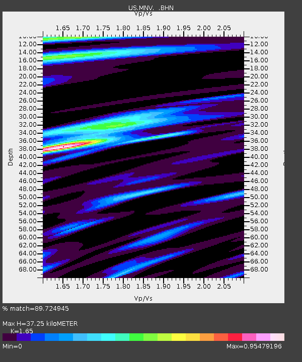
| Estimated Moho Depth: |
37.25 km |
| Estimated Crust Vp/Vs: |
1.65 |
| Assumed Crust Vp: |
6.279 km/s |
| Estimated Crust Vs: |
3.805 km/s |
| Estimated Crust Poisson's Ratio: |
0.21 |
|
| Radial Match: |
89.724945 % |
| Radial Bump: |
400 |
| Transverse Match: |
83.829124 % |
| Transverse Bump: |
400 |
| SOD ConfigId: |
110165 |
| Insert Time: |
2010-03-05 06:50:02.692 +0000 |
| GWidth: |
2.5 |
| Max Bumps: |
400 |
| Tol: |
0.001 |
|

Signal To Noise
| Channel | StoN | STA | LTA |
| US:MNV: :BHN:20030930T14:20:56.39802Z | 1.5884341 | 1.0575578E-7 | 6.6578636E-8 |
| US:MNV: :BHE:20030930T14:20:56.39802Z | 1.64092 | 1.1399691E-7 | 6.9471334E-8 |
| US:MNV: :BHZ:20030930T14:20:56.39802Z | 1.6072197 | 2.000381E-7 | 1.244622E-7 |
| Arrivals |
| Ps | 3.9 SECOND |
| PpPs | 15 SECOND |
| PsPs/PpSs | 19 SECOND |


