You are here: Home > Network List > US - United States National Seismic Network Stations List
> Station MNV Mina, Nevada, USA > Earthquake Result Viewer
MNV Mina, Nevada, USA - Earthquake Result Viewer
| Earthquake location: |
Central East Pacific Rise |
| Earthquake latitude/longitude: |
-4.6/-106.0 |
| Earthquake time(UTC): |
2003/09/06 (249) 02:08:13 GMT |
| Earthquake Depth: |
10 km |
| Earthquake Magnitude: |
5.4 MB, 5.8 MS, 6.1 MW, 6.0 MW |
| Earthquake Catalog/Contributor: |
WHDF/NEIC |
|
| Network: |
US United States National Seismic Network |
| Station: |
MNV Mina, Nevada, USA |
| Lat/Lon: |
38.43 N/118.15 W |
| Elevation: |
1524 m |
|
| Distance: |
44.3 deg |
| Az: |
346.353 deg |
| Baz: |
162.576 deg |
| Ray Param: |
0.07201028 |
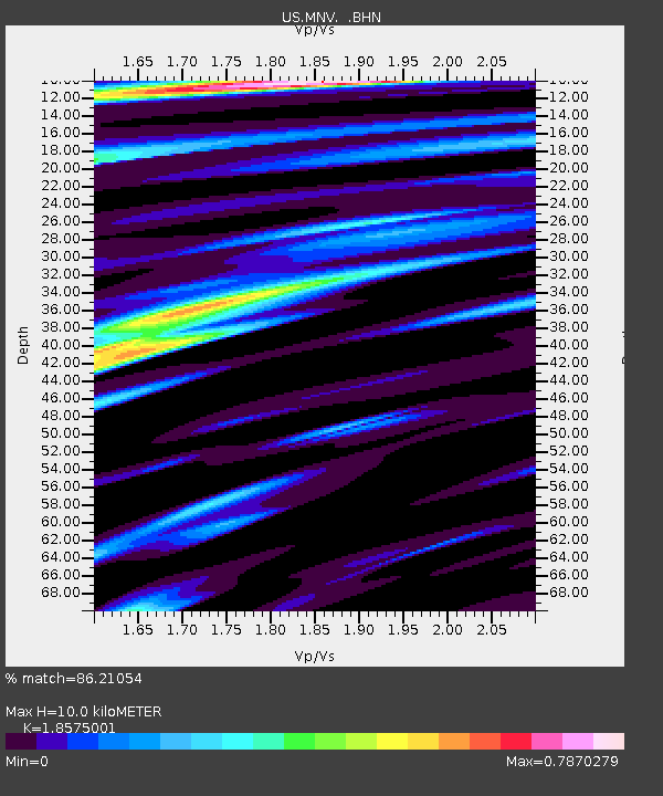
| Estimated Moho Depth: |
10.0 km |
| Estimated Crust Vp/Vs: |
1.86 |
| Assumed Crust Vp: |
6.279 km/s |
| Estimated Crust Vs: |
3.38 km/s |
| Estimated Crust Poisson's Ratio: |
0.30 |
|
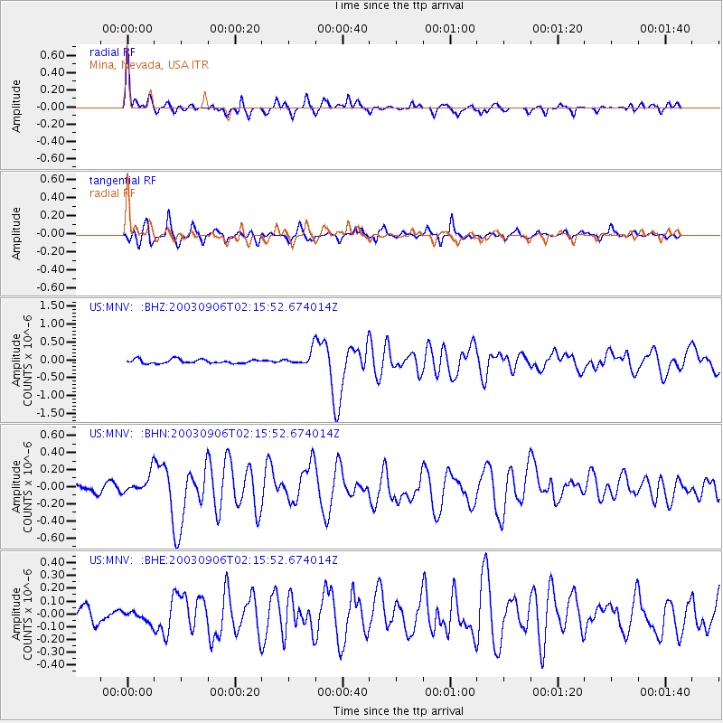
| Radial Match: |
86.21054 % |
| Radial Bump: |
400 |
| Transverse Match: |
78.07412 % |
| Transverse Bump: |
400 |
| SOD ConfigId: |
110165 |
| Insert Time: |
2010-03-05 06:50:05.497 +0000 |
| GWidth: |
2.5 |
| Max Bumps: |
400 |
| Tol: |
0.001 |
|
Signal To Noise
| Channel | StoN | STA | LTA |
| US:MNV: :BHN:20030906T02:15:52.674014Z | 1.7756715 | 1.17282916E-7 | 6.60499E-8 |
| US:MNV: :BHE:20030906T02:15:52.674014Z | 0.7522351 | 4.389238E-8 | 5.8349286E-8 |
| US:MNV: :BHZ:20030906T02:15:52.674014Z | 3.8202357 | 2.1299164E-7 | 5.5753528E-8 |
| Arrivals |
| Ps | 1.4 SECOND |
| PpPs | 4.3 SECOND |
| PsPs/PpSs | 5.7 SECOND |


