You are here: Home > Network List > US - United States National Seismic Network Stations List
> Station MNV Mina, Nevada, USA > Earthquake Result Viewer
MNV Mina, Nevada, USA - Earthquake Result Viewer
| Earthquake location: |
Kermadec Islands, New Zealand |
| Earthquake latitude/longitude: |
-30.5/-178.2 |
| Earthquake time(UTC): |
2003/05/04 (124) 13:15:18 GMT |
| Earthquake Depth: |
62 km |
| Earthquake Magnitude: |
6.0 MB, 6.5 MS, 6.7 MW, 6.7 MW |
| Earthquake Catalog/Contributor: |
WHDF/NEIC |
|
| Network: |
US United States National Seismic Network |
| Station: |
MNV Mina, Nevada, USA |
| Lat/Lon: |
38.43 N/118.15 W |
| Elevation: |
1524 m |
|
| Distance: |
88.6 deg |
| Az: |
42.914 deg |
| Baz: |
228.424 deg |
| Ray Param: |
0.04238084 |
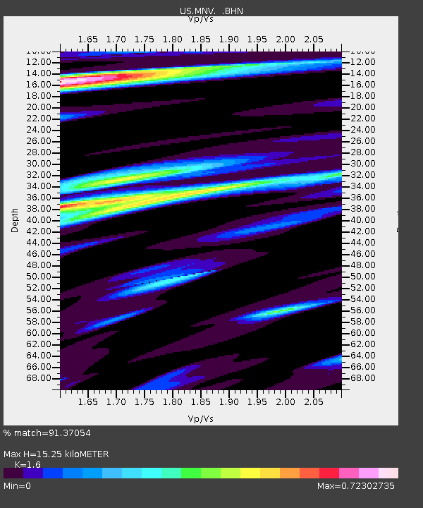
| Estimated Moho Depth: |
15.25 km |
| Estimated Crust Vp/Vs: |
1.60 |
| Assumed Crust Vp: |
6.279 km/s |
| Estimated Crust Vs: |
3.924 km/s |
| Estimated Crust Poisson's Ratio: |
0.18 |
|
| Radial Match: |
91.37054 % |
| Radial Bump: |
400 |
| Transverse Match: |
77.07091 % |
| Transverse Bump: |
400 |
| SOD ConfigId: |
110177 |
| Insert Time: |
2010-03-05 06:50:10.515 +0000 |
| GWidth: |
2.5 |
| Max Bumps: |
400 |
| Tol: |
0.001 |
|
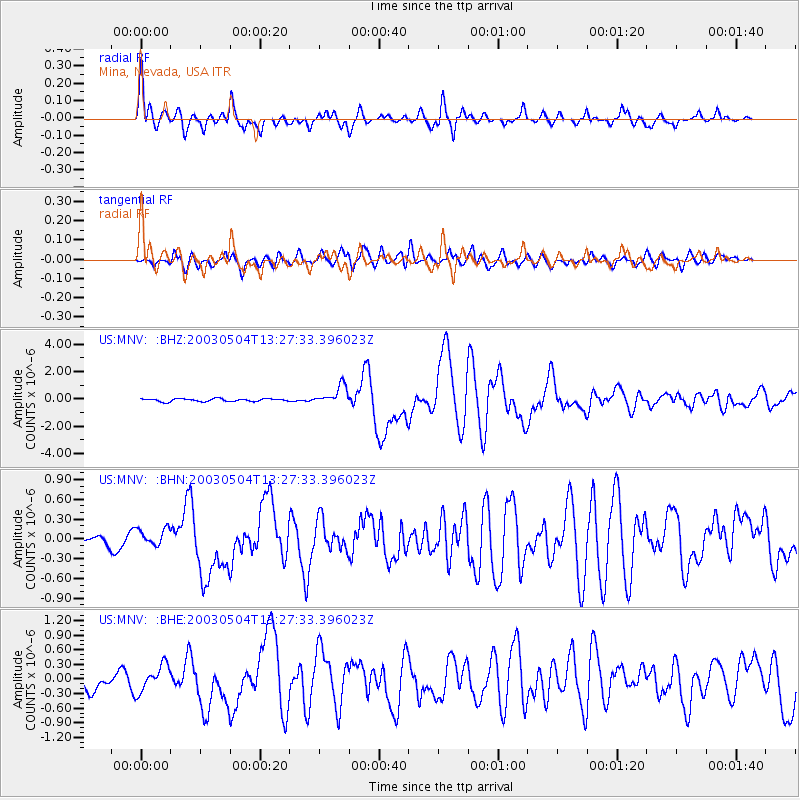
Signal To Noise
| Channel | StoN | STA | LTA |
| US:MNV: :BHN:20030504T13:27:33.396023Z | 1.4371133 | 1.2521816E-7 | 8.713173E-8 |
| US:MNV: :BHE:20030504T13:27:33.396023Z | 1.8547451 | 2.723152E-7 | 1.4682081E-7 |
| US:MNV: :BHZ:20030504T13:27:33.396023Z | 6.671921 | 6.9496235E-7 | 1.0416226E-7 |
| Arrivals |
| Ps | 1.5 SECOND |
| PpPs | 6.2 SECOND |
| PsPs/PpSs | 7.7 SECOND |


