You are here: Home > Network List > US - United States National Seismic Network Stations List
> Station MNV Mina, Nevada, USA > Earthquake Result Viewer
MNV Mina, Nevada, USA - Earthquake Result Viewer
| Earthquake location: |
Kermadec Islands, New Zealand |
| Earthquake latitude/longitude: |
-30.6/-178.3 |
| Earthquake time(UTC): |
2003/05/04 (124) 20:08:46 GMT |
| Earthquake Depth: |
46 km |
| Earthquake Magnitude: |
6.0 MB, 6.1 MS, 6.4 MW, 6.4 MW |
| Earthquake Catalog/Contributor: |
WHDF/NEIC |
|
| Network: |
US United States National Seismic Network |
| Station: |
MNV Mina, Nevada, USA |
| Lat/Lon: |
38.43 N/118.15 W |
| Elevation: |
1524 m |
|
| Distance: |
88.6 deg |
| Az: |
42.943 deg |
| Baz: |
228.422 deg |
| Ray Param: |
0.04236654 |
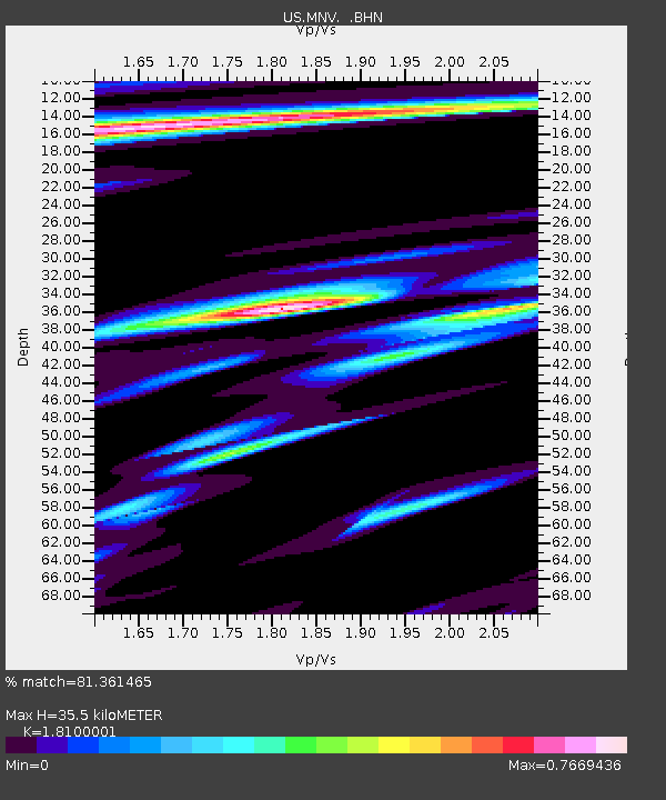
| Estimated Moho Depth: |
35.5 km |
| Estimated Crust Vp/Vs: |
1.81 |
| Assumed Crust Vp: |
6.279 km/s |
| Estimated Crust Vs: |
3.469 km/s |
| Estimated Crust Poisson's Ratio: |
0.28 |
|
| Radial Match: |
81.361465 % |
| Radial Bump: |
400 |
| Transverse Match: |
61.951603 % |
| Transverse Bump: |
400 |
| SOD ConfigId: |
110177 |
| Insert Time: |
2010-03-05 06:50:12.564 +0000 |
| GWidth: |
2.5 |
| Max Bumps: |
400 |
| Tol: |
0.001 |
|
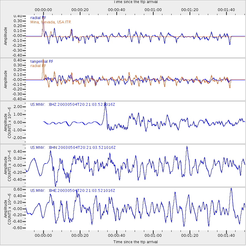
Signal To Noise
| Channel | StoN | STA | LTA |
| US:MNV: :BHN:20030504T20:21:03.521016Z | 1.5505211 | 1.7355438E-7 | 1.1193294E-7 |
| US:MNV: :BHE:20030504T20:21:03.521016Z | 2.816829 | 2.6457565E-7 | 9.392677E-8 |
| US:MNV: :BHZ:20030504T20:21:03.521016Z | 7.6921296 | 1.0147726E-6 | 1.3192349E-7 |
| Arrivals |
| Ps | 4.7 SECOND |
| PpPs | 16 SECOND |
| PsPs/PpSs | 20 SECOND |


