You are here: Home > Network List > TA - USArray Transportable Network (new EarthScope stations) Stations List
> Station T25A Trinidad, CO, USA > Earthquake Result Viewer
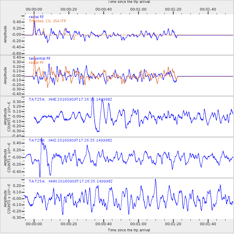
T25A Trinidad, CO, USA - Earthquake Result Viewer
*The percent match for this event was below the threshold and hence no stack was calculated.
| Earthquake location: |
Northern Mid-Atlantic Ridge |
| Earthquake latitude/longitude: |
22.1/-45.9 |
| Earthquake time(UTC): |
2016/09/09 (253) 17:17:54 GMT |
| Earthquake Depth: |
10 km |
| Earthquake Magnitude: |
5.5 MB |
| Earthquake Catalog/Contributor: |
NEIC PDE/NEIC COMCAT |
|
| Network: |
TA USArray Transportable Network (new EarthScope stations) |
| Station: |
T25A Trinidad, CO, USA |
| Lat/Lon: |
37.14 N/104.41 W |
| Elevation: |
2017 m |
|
| Distance: |
52.3 deg |
| Az: |
300.493 deg |
| Baz: |
89.405 deg |
| Ray Param: |
$rayparam |
*The percent match for this event was below the threshold and hence was not used in the summary stack. |
|
| Radial Match: |
50.570652 % |
| Radial Bump: |
400 |
| Transverse Match: |
59.85301 % |
| Transverse Bump: |
400 |
| SOD ConfigId: |
11737051 |
| Insert Time: |
2019-04-25 11:48:31.283 +0000 |
| GWidth: |
2.5 |
| Max Bumps: |
400 |
| Tol: |
0.001 |
|
Signal To Noise
| Channel | StoN | STA | LTA |
| TA:T25A: :HHZ:20160909T17:26:35.149998Z | 2.8024268 | 2.4906134E-7 | 8.8873456E-8 |
| TA:T25A: :HHN:20160909T17:26:35.149998Z | 0.5073126 | 5.3076942E-8 | 1.04623744E-7 |
| TA:T25A: :HHE:20160909T17:26:35.149998Z | 2.8298733 | 1.5261085E-7 | 5.3928506E-8 |
| Arrivals |
| Ps | |
| PpPs | |
| PsPs/PpSs | |


