You are here: Home > Network List > UW - Pacific Northwest Regional Seismic Network Stations List
> Station PASS Maple Falls, WA, USA > Earthquake Result Viewer
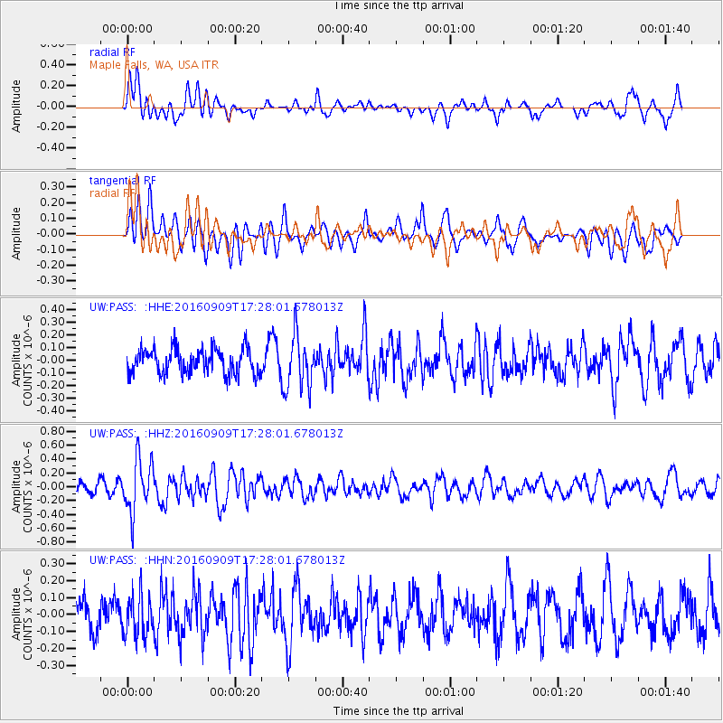
PASS Maple Falls, WA, USA - Earthquake Result Viewer
*The percent match for this event was below the threshold and hence no stack was calculated.
| Earthquake location: |
Northern Mid-Atlantic Ridge |
| Earthquake latitude/longitude: |
22.1/-45.9 |
| Earthquake time(UTC): |
2016/09/09 (253) 17:17:54 GMT |
| Earthquake Depth: |
10 km |
| Earthquake Magnitude: |
5.5 MB |
| Earthquake Catalog/Contributor: |
NEIC PDE/NEIC COMCAT |
|
| Network: |
UW Pacific Northwest Regional Seismic Network |
| Station: |
PASS Maple Falls, WA, USA |
| Lat/Lon: |
49.00 N/122.09 W |
| Elevation: |
174 m |
|
| Distance: |
64.7 deg |
| Az: |
314.978 deg |
| Baz: |
84.902 deg |
| Ray Param: |
$rayparam |
*The percent match for this event was below the threshold and hence was not used in the summary stack. |
|
| Radial Match: |
66.114426 % |
| Radial Bump: |
400 |
| Transverse Match: |
62.476555 % |
| Transverse Bump: |
400 |
| SOD ConfigId: |
11737051 |
| Insert Time: |
2019-04-25 11:49:09.578 +0000 |
| GWidth: |
2.5 |
| Max Bumps: |
400 |
| Tol: |
0.001 |
|
Signal To Noise
| Channel | StoN | STA | LTA |
| UW:PASS: :HHZ:20160909T17:28:01.678013Z | 3.53023 | 3.8558642E-7 | 1.0922416E-7 |
| UW:PASS: :HHN:20160909T17:28:01.678013Z | 1.3034248 | 1.226754E-7 | 9.4117745E-8 |
| UW:PASS: :HHE:20160909T17:28:01.678013Z | 2.1436498 | 2.1131738E-7 | 9.857832E-8 |
| Arrivals |
| Ps | |
| PpPs | |
| PsPs/PpSs | |


