You are here: Home > Network List > US - United States National Seismic Network Stations List
> Station MNV Mina, Nevada, USA > Earthquake Result Viewer
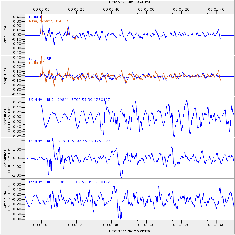
MNV Mina, Nevada, USA - Earthquake Result Viewer
*The percent match for this event was below the threshold and hence no stack was calculated.
| Earthquake location: |
Fiji Islands Region |
| Earthquake latitude/longitude: |
-21.6/-176.5 |
| Earthquake time(UTC): |
1998/11/15 (319) 02:44:12 GMT |
| Earthquake Depth: |
149 km |
| Earthquake Magnitude: |
5.9 MB, 6.3 UNKNOWN, 6.2 MW |
| Earthquake Catalog/Contributor: |
WHDF/NEIC |
|
| Network: |
US United States National Seismic Network |
| Station: |
MNV Mina, Nevada, USA |
| Lat/Lon: |
38.43 N/118.15 W |
| Elevation: |
1524 m |
|
| Distance: |
81.0 deg |
| Az: |
42.607 deg |
| Baz: |
233.344 deg |
| Ray Param: |
$rayparam |
*The percent match for this event was below the threshold and hence was not used in the summary stack. |
|
| Radial Match: |
79.41132 % |
| Radial Bump: |
400 |
| Transverse Match: |
59.744637 % |
| Transverse Bump: |
400 |
| SOD ConfigId: |
4480 |
| Insert Time: |
2010-03-05 06:50:33.009 +0000 |
| GWidth: |
2.5 |
| Max Bumps: |
400 |
| Tol: |
0.001 |
|
Signal To Noise
| Channel | StoN | STA | LTA |
| US:MNV: :BHN:19981115T02:55:39.125012Z | 4.7812147 | 5.971398E-7 | 1.248929E-7 |
| US:MNV: :BHE:19981115T02:55:39.125012Z | 0.79678774 | 1.09554904E-7 | 1.3749572E-7 |
| US:MNV: :BHZ:19981115T02:55:39.125012Z | 1.0623469 | 2.2518725E-7 | 2.1197147E-7 |
| Arrivals |
| Ps | |
| PpPs | |
| PsPs/PpSs | |


