You are here: Home > Network List > US - United States National Seismic Network Stations List
> Station MNV Mina, Nevada, USA > Earthquake Result Viewer
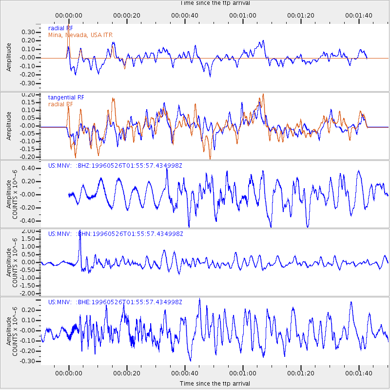
MNV Mina, Nevada, USA - Earthquake Result Viewer
*The percent match for this event was below the threshold and hence no stack was calculated.
| Earthquake location: |
Southeast Of Loyalty Islands |
| Earthquake latitude/longitude: |
-22.2/171.5 |
| Earthquake time(UTC): |
1996/05/26 (147) 01:43:44 GMT |
| Earthquake Depth: |
108 km |
| Earthquake Magnitude: |
5.6 MB, 6.1 UNKNOWN, 6.1 MW |
| Earthquake Catalog/Contributor: |
WHDF/NEIC |
|
| Network: |
US United States National Seismic Network |
| Station: |
MNV Mina, Nevada, USA |
| Lat/Lon: |
38.43 N/118.15 W |
| Elevation: |
1524 m |
|
| Distance: |
89.3 deg |
| Az: |
47.713 deg |
| Baz: |
240.812 deg |
| Ray Param: |
$rayparam |
*The percent match for this event was below the threshold and hence was not used in the summary stack. |
|
| Radial Match: |
60.700645 % |
| Radial Bump: |
400 |
| Transverse Match: |
57.506016 % |
| Transverse Bump: |
400 |
| SOD ConfigId: |
4480 |
| Insert Time: |
2010-03-05 06:50:38.173 +0000 |
| GWidth: |
2.5 |
| Max Bumps: |
400 |
| Tol: |
0.001 |
|
Signal To Noise
| Channel | StoN | STA | LTA |
| US:MNV: :BHN:19960526T01:55:57.434998Z | 5.080633 | 5.7123646E-7 | 1.1243411E-7 |
| US:MNV: :BHE:19960526T01:55:57.434998Z | 0.9948489 | 6.923509E-8 | 6.959357E-8 |
| US:MNV: :BHZ:19960526T01:55:57.434998Z | 1.2783226 | 1.541218E-7 | 1.2056566E-7 |
| Arrivals |
| Ps | |
| PpPs | |
| PsPs/PpSs | |


