You are here: Home > Network List > US - United States National Seismic Network Stations List
> Station MNV Mina, Nevada, USA > Earthquake Result Viewer
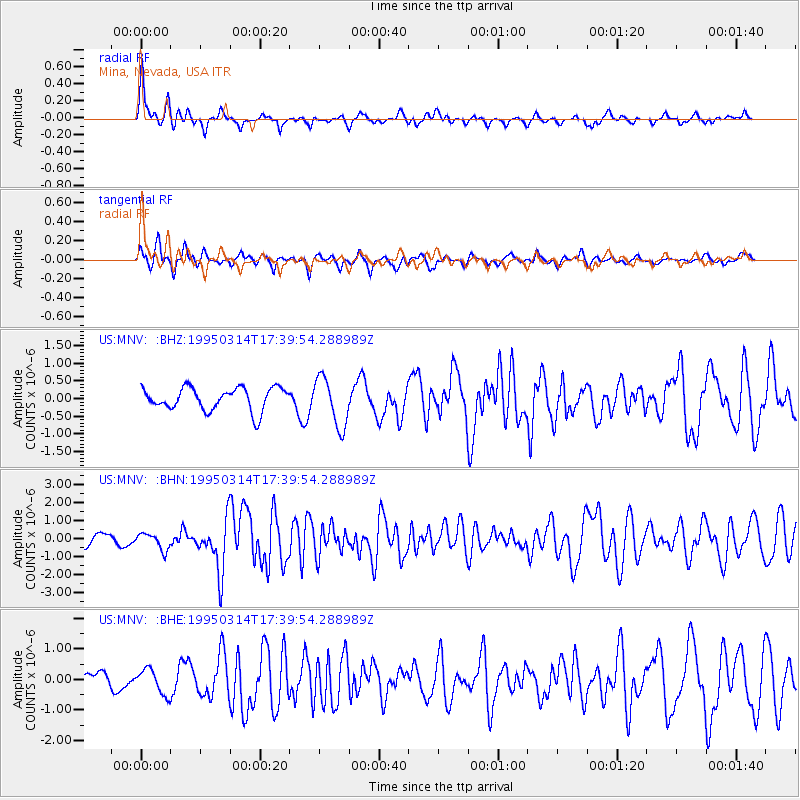
MNV Mina, Nevada, USA - Earthquake Result Viewer
*The percent match for this event was below the threshold and hence no stack was calculated.
| Earthquake location: |
Alaska Peninsula |
| Earthquake latitude/longitude: |
54.8/-161.3 |
| Earthquake time(UTC): |
1995/03/14 (073) 17:33:50 GMT |
| Earthquake Depth: |
33 km |
| Earthquake Magnitude: |
6.1 MB, 5.9 MS, 6.2 UNKNOWN, 5.5 ML |
| Earthquake Catalog/Contributor: |
WHDF/NEIC |
|
| Network: |
US United States National Seismic Network |
| Station: |
MNV Mina, Nevada, USA |
| Lat/Lon: |
38.43 N/118.15 W |
| Elevation: |
1524 m |
|
| Distance: |
33.2 deg |
| Az: |
101.441 deg |
| Baz: |
313.719 deg |
| Ray Param: |
$rayparam |
*The percent match for this event was below the threshold and hence was not used in the summary stack. |
|
| Radial Match: |
77.58178 % |
| Radial Bump: |
400 |
| Transverse Match: |
54.239044 % |
| Transverse Bump: |
400 |
| SOD ConfigId: |
4480 |
| Insert Time: |
2010-03-05 06:50:41.359 +0000 |
| GWidth: |
2.5 |
| Max Bumps: |
400 |
| Tol: |
0.001 |
|
Signal To Noise
| Channel | StoN | STA | LTA |
| US:MNV: :BHN:19950314T17:39:54.288989Z | 1.2812979 | 4.621594E-7 | 3.6069625E-7 |
| US:MNV: :BHE:19950314T17:39:54.288989Z | 1.015873 | 4.0703796E-7 | 4.0067803E-7 |
| US:MNV: :BHZ:19950314T17:39:54.288989Z | 2.1939836 | 7.0105295E-7 | 3.1953428E-7 |
| Arrivals |
| Ps | |
| PpPs | |
| PsPs/PpSs | |


